
李家圪塔村 topographic map
Interactive map
Click on the map to display elevation.
About this map
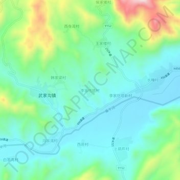
Name: 李家圪塔村 topographic map, elevation, terrain.
Location: 李家圪塔村, 张家口市, 河北省, 中国 (40.32794 115.04943 40.36794 115.08943)
Average elevation: 700 m
Minimum elevation: 581 m
Maximum elevation: 1,049 m
Other topographic maps
Click on a map to view its topography, its elevation and its terrain.