
沙岭子镇 topographic map
Interactive map
Click on the map to display elevation.
About this map
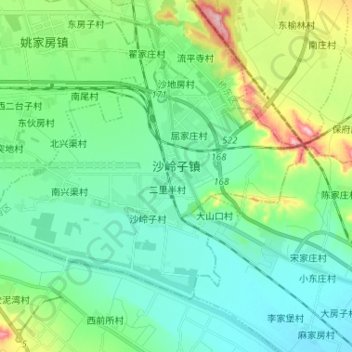
Name: 沙岭子镇 topographic map, elevation, terrain.
Location: 沙岭子镇, 桥西区, 张家口市, 河北省, 075000, 中国 (40.64334 114.83724 40.71207 114.96722)
Average elevation: 665 m
Minimum elevation: 615 m
Maximum elevation: 825 m
Other topographic maps
Click on a map to view its topography, its elevation and its terrain.