
李家堡乡 topographic map
Interactive map
Click on the map to display elevation.
About this map
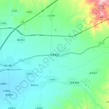
Name: 李家堡乡 topographic map, elevation, terrain.
Location: 李家堡乡, 张家口市, 河北省, 中国 (40.64929 115.35116 40.72929 115.43116)
Average elevation: 908 m
Minimum elevation: 764 m
Maximum elevation: 1,475 m
Other topographic maps
Click on a map to view its topography, its elevation and its terrain.