
Make a donation
Poland topographic map
Click on the map to display elevation.
Make a donation
Poland
Poland's topography is characterized by a diverse landscape that transitions from the Baltic Sea's sandy beaches in the north to mountainous regions in the south. The northern coastline features sand dunes and is indented by spits and lagoons, such as the Hel Peninsula and the Vistula Lagoon. Moving inland, the terrain is shaped by glacial activity, resulting in numerous lakes and gentle hills, particularly evident in the Masurian Lake District, which boasts over 2,000 lakes amidst dense forests. Central Poland is dominated by the expansive Polish Plain, a flat region crisscrossed by major rivers like the Vistula and the Oder, making it ideal for agriculture. Further south, the landscape becomes more varied with uplands and highlands, including the Lesser Poland Uplands, characterized by rolling hills and fertile valleys. The southernmost part of the country is marked by the Sudeten and Carpathian mountain ranges. The Carpathians encompass the Tatra Mountains, where Poland's highest peak, Mount Rysy, reaches 2,501 meters (8,205 feet). This diverse terrain supports a rich array of ecosystems and contributes to Poland's varied climate patterns.
Make a donation
About this map
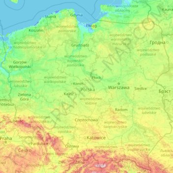
Name: Poland topographic map, elevation, terrain.
Location: Poland (49.00205 14.06964 55.03605 24.14578)
Average elevation: 194 m
Minimum elevation: -6 m
Maximum elevation: 2,237 m
Make a donation
Other topographic maps
Click on a map to view its topography, its elevation and its terrain.
Istanbul
Istanbul, located in northwestern Turkey, is a city that is uniquely situated across two continents, Europe and Asia, divided by the Bosphorus Strait. The city’s topography is characterized by a complex blend of hills, valleys, and coastal plains, which create a varied and scenic landscape. The European side…
Average elevation: 57 m
Bangladesh
With an elevation of 1,064 m (3,491 ft), Saka Haphong (also known as Mowdok Mual) near the border with Myanmar, is claimed to be the highest peak of Bangladesh. However, it is not yet widely recognized as the highest point of the country, and most sources give the honor to Keokradong.
Average elevation: 1,488 m
Chiang Mai
Chiang Mai has a tropical savanna climate (Köppen Aw), tempered by the low latitude and moderate elevation, with warm to hot weather year-round, though nighttime conditions during the dry season can be cool and much lower than daytime highs. The maximum temperature ever recorded was 42.4 °C (108.3 °F) in…
Average elevation: 424 m
Make a donation
Featherston
New Zealand > Wellington > South Wairarapa District > Featherston Community
Average elevation: 125 m
Make a donation
Maseru
Maseru is located in northwest Lesotho by the South African border, denoted by the Mohokare River, also known as Caledon River. The two countries are connected by a border post at the Maseru Bridge, which crosses the river. On the South African side, Ladybrand is the town closest to Maseru. The city lies in a…
Average elevation: 1,606 m
Make a donation
Make a donation
Make a donation
Make a donation
Anbar sar
Iran > Gilan Province > Astaneh-ye Ashrafiyeh County > دهستان دهگاه
Average elevation: -25 m
Phu Kradung
Thailand > Phu Kradueng District
Phu Kradueng National Park (Thai: อุทยานแห่งชาติภูกระดึง), in the Si Than sub-district of Amphoe Phu Kradueng, Loei Province, is a national park in Thailand. It has a high point of 1,316 m (4318 ft) elevation at Khok Moei. It was proclaimed a national park on 23…
Average elevation: 1,183 m
Make a donation
Chattogram
Bangladesh > Chattogram Division > Chittagong City
Chittagong lies at 22°20′06″N 91°49′57″E / 22.33500°N 91.83250°E / 22.33500; 91.83250. It straddles the coastal foothills of the Chittagong Hill Tracts in south-eastern Bangladesh. The Karnaphuli River runs along the southern banks of the city, including its central business district. The…
Average elevation: 6 m
Floreaga
Spain > Autonomous Community of the Basque Country > Urola-Kosta > Azkoitia
Average elevation: 266 m
Make a donation
Make a donation
Murree
Pakistan > Punjab > Murree District
Murree is a mountain resort city in the northernmost region of the Punjab province of Pakistan. Lying in the Galyat region of the Pir Panjal Range under the western Himalayas, it is located in the northeast of the capital city of Islamabad. The town was built in the mid-19th century and served as the summer…
Average elevation: 1,718 m
Mauna Kea
United States > Hawaii > Hawaiʻi County
Mauna Kea (/ˌmɔːnə ˈkeɪə, ˌmaʊnə -/, Hawaiian: [ˈmɐwnə ˈkɛjə]; abbreviation for Mauna a Wākea, 'White Mountain') is a dormant shield volcano on the island of Hawaiʻi. Its peak is 4,207.3 m (13,803 ft) above sea level, making it the highest point in Hawaii and the island with the second…
Average elevation: 3,978 m
South America
One of the earliest known South American civilizations was Caral–Supe, on the central Peruvian coast. Though a pre-ceramic culture, the monumental architecture of Caral–Supe created one of the first cities of the world, generally dated to around 3500 BC, at Huaricanga in the Fortaleza area, contemporaneous…
Average elevation: 283 m
Make a donation
Memel
South Africa > Free State > Thabo Mofutsanyana District Municipality > Phumelela Local Municipality
Memel-Zamani lies in the west-facing lee of the Drakensberg escarpment, the escarpment functioning as the continental divide. Its high elevation and close proximity to the escarpment are the major reason for Memel's cold winters. Visitors are frequently surprised by just how cold winter can be in Memel. Added…
Average elevation: 1,723 m
Make a donation
Hoodoo Mountain
Canada > British Columbia > Regional District of Kitimat-Stikine > Area D (Iskut/Big Raven)
Hoodoo Mountain, sometimes referred to as Hoodoo Volcano, is a potentially active stratovolcano in the Northern Interior of British Columbia, Canada. It is located 25 kilometres (16 miles) northeast of the Alaska–British Columbia border on the north side of the Iskut River opposite of the mouth of the Craig…
Average elevation: 1,657 m
Make a donation
Antananarivo
Antananarivo (Malagasy: [antananaˈrivʷ]; French: Tananarive, pronounced [tananaʁiv]), also known by its colonial shorthand form Tana (pronounced [tana]), is the capital and largest city of Madagascar. The administrative area of the city, known as Antananarivo-Renivohitra ("Antananarivo-Mother Hill" or…
Average elevation: 1,309 m
Make a donation
North America
Average elevation: 294 m
Make a donation
Make a donation
Sunset Peak
Sunset Peak is only accessible by foot. It is located on section 2 of the 70 km (43 mi) long Lantau Trail. Section 2 is 6.5 km long and goes from Nam Shan Campsite west of Mui Wo on South Lantau Road (elevation about 120 m), to Pak Kung Au, another campsite on the Tung Chung Road (elevation about 340 m). Both…
Average elevation: 411 m
Himalayas
The Himalayas, or Himalaya (/ˌhɪməˈleɪ.ə, hɪˈmɑːləjə/ HIM-ə-LAY-ə, hih-MAH-lə-yə), is a mountain range in Asia, separating the plains of the Indian subcontinent from the Tibetan Plateau. The range has some of the Earth's highest peaks, including the highest, Mount Everest. More than 100 peaks…
Average elevation: 2,385 m
Koytendag
Turkmenistan > Koytendag District
Köýtendag is located at an altitude of 265 meters on the banks of the Amu-Darya River, which forms the border with Jowzjan Province, Afghanistan. The Afghan town of Qarqin is on the opposite side of the river. Köýtendag is near the eastern end of Lebap Province, and indeed all of Turkmenistan. The plains…
Average elevation: 277 m
Make a donation
Réserve Naturelle Intégrale des Tsingy de Bemaraha
Madagascar > Melaky > Antsalova
Average elevation: 103 m
Mount Judi
The Arabic word al-Jūdiyy (ٱلْجُودِيّ), originates from the Syriac word Gudo (ܓܘܕܐ) meaning "Mounds" or "Elevations". The relation of some of the spellings is clear. The origin of Judi is less clear. It is usually interpreted as a corrupted version of the same name, via Al-Gurdi (Reynolds 2004).…
Average elevation: 1,904 m
Make a donation
Make a donation
Rocky Mountains
Canada > British Columbia > Peace River Regional District > Area D (Kiskatinaw Valley)
Average elevation: 1,252 m
Make a donation
Frills Corners
United States > Pennsylvania > Clarion County > Washington Township
Average elevation: 482 m
Make a donation