
Thank you for supporting this site ❤️
Make a donation
Make a donation
Terril du Martinet topographic map
Click on the map to display elevation.
Thank you for supporting this site ❤️
Make a donation
Make a donation
About this map
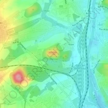
Name: Terril du Martinet topographic map, elevation, terrain.
Location: Terril du Martinet, Charleroi, Hainaut, Wallonia, 6044, Belgium (50.43207 4.38006 50.43217 4.38016)
Average elevation: 133 m
Minimum elevation: 101 m
Maximum elevation: 214 m
Thank you for supporting this site ❤️
Make a donation
Make a donation
Other topographic maps
Click on a map to view its topography, its elevation and its terrain.