
Bangladesh topographic map
Interactive map
Click on the map to display elevation.
Bangladesh
With an elevation of 1,064 m (3,491 ft), Saka Haphong (also known as Mowdok Mual) near the border with Myanmar, is claimed to be the highest peak of Bangladesh. However, it is not yet widely recognized as the highest point of the country, and most sources give the honor to Keokradong.
About this map
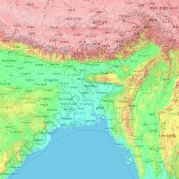
Name: Bangladesh topographic map, elevation, terrain.
Location: Bangladesh (17.47688 83.29324 31.47688 97.29324)
Average elevation: 1,488 m
Minimum elevation: -3 m
Maximum elevation: 7,813 m
Other topographic maps
Click on a map to view its topography, its elevation and its terrain.