
Make a donation
North America topographic map
Click on the map to display elevation.
Make a donation
About this map
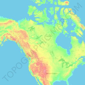
Name: North America topographic map, elevation, terrain.
Location: North America (26.00000 -134.00000 76.00000 -84.00000)
Average elevation: 294 m
Minimum elevation: -2 m
Maximum elevation: 5,837 m
Make a donation
Other topographic maps
Click on a map to view its topography, its elevation and its terrain.
Norway
At 385,207 square kilometres (148,729 sq mi) (including Svalbard and Jan Mayen; 323,808 square kilometres (125,023 sq mi) without), much of the country is dominated by mountainous or high terrain, with a great variety of natural features caused by prehistoric glaciers and varied topography. The most noticeable…
Average elevation: 143 m
Pulau Bali
Bali's central mountains include several peaks over 2,000 metres (6,600 feet) in elevation and active volcanoes such as Mount Batur. The highest is Mount Agung (3,031 m; 9,944 ft), known as the "mother mountain", which is an active volcano rated as one of the world's most likely sites for a massive eruption…
Average elevation: 122 m
Make a donation
France
Metropolitan France has a wide variety of topographic sets and natural landscapes. During the Hercynian uplift in the Paleozoic Era, the Armorican Massif, the Massif Central, the Morvan, the Vosges and Ardennes ranges and the island of Corsica were formed. These massifs delineate several sedimentary basins…
Average elevation: 430 m
Make a donation
Malaysia
The two parts of Malaysia, separated from each other by the South China Sea, share a largely similar landscape in that both Peninsular and East Malaysia feature coastal plains rising to hills and mountains. Peninsular Malaysia, containing 40% of Malaysia's land area, extends 740 km (460 mi) from north to…
Average elevation: 54 m
Make a donation
Gran Canaria
Gran Canaria is located in the Atlantic Ocean in a region known as Macaronesia about 150 kilometres (93 mi) off the northwestern coast of Africa and about 1,350 km (840 mi) from Europe. With an area of 1,560 km2 (600 sq mi) and an altitude of 1,956 m (6,417 ft) at Morro de la Agujereada, Gran Canaria is the…
Average elevation: 335 m
Make a donation
Turkey
Turkey's topography is a diverse tapestry of mountains, plateaus, and coastal plains that create a strikingly varied landscape. The country is predominantly characterized by the Anatolian Plateau, a semi-arid highland that stretches across central Turkey, with elevations ranging from 700 to 2,000 meters. This…
Average elevation: 487 m
Municipality of Minoa Pediados
Greece > Region of Crete > Heraklion Regional Unit
Average elevation: 438 m
Make a donation
Make a donation
Netherlands
Average elevation: 252 m
Make a donation
Palma de Mallorca
Spain > Balearic Islands > Palma
Palma is a major city and seaport located in the southwest of Mallorca, a western Mediterranean island belonging to the Balearic Islands archipelago. The land area of the city is about 21.355 square kilometres (8.245 sq mi) with an altitude of 13 metres (43 feet) above sea level.
Average elevation: 45 m
Langzhong City
Langzhong is located in the northeast of the province and the northern part of the Sichuan Basin on the middle reaches of the Jialing River. Within the city's administrative area, elevations generally increase from southwest to northeast and range from 328 metres (1,076 ft) to 888 metres (2,913 ft), while…
Average elevation: 480 m
Make a donation
Make a donation
Tehran
Iran > Tehran Province > Tehran County
Northern Tehran is at the foot of Alborz, starting at an elevation of 1,800 meters (5,900 ft), with many houses and streets on steep slopes and hills. There is a stretch of hills in the middle of the city (which historically divided Tehran and Shemiran) with its highest point at 1,500 metres (4,900 ft).…
Average elevation: 1,539 m
São Paulo
Brazil > São Paulo > Região Metropolitana de São Paulo
The city is on a plateau placed beyond the Serra do Mar (Portuguese for "Sea Range" or "Coastal Range"), itself a component of the vast region known as the Brazilian Highlands, with an average elevation of around 799 meters (2,621 ft) above sea level, although being at a distance of only about 70 kilometers…
Average elevation: 716 m
Make a donation
Make a donation
Berkshire County
Running north-south through the county are the Hoosac Range of the Berkshire Hills in the eastern part of the county and the Taconic Mountains in the western part of the county. Due to their elevation, the Berkshires attract tourists and summer residents eager to escape the heat of the lowlands.
Average elevation: 359 m
Make a donation
Malinao
There was no concentration of land holdings by few families, unlike in other areas of the country. Original families in Malinao have their own pieces of land to work on. The land west of the Aklan River, because of its topography, must have escaped the encomienderos and hacienderos in the early part of Spanish…
Average elevation: 89 m
Fox Glacier
New Zealand > West Coast > Westland District
Chancellor Hut was built in 1930–31 on the southwest face of Chancellor Ridge, now 200 m above the glacier. Planned by mountain guides Alec and Peter Graham in 1929, all the materials had to be packed up Fox Glacier manually in 1930 in the days before helicopter airlifts. It is the oldest remaining mountain…
Average elevation: 1,848 m
Make a donation
Make a donation
Make a donation
Coimbra
Despite being relatively distant from the coast, Coimbra also has a marked Atlantic influence due to the floodplain of the Mondego River which crosses the city, making both its winters and summers milder than they would otherwise be. This influence also makes cold waves less frequent and less intense, however,…
Average elevation: 129 m
British Columbia
The Southern Interior cities of Kamloops and Penticton have some of the warmest and longest summer climates in Canada (while higher elevations are cold and snowy), although their temperatures are often exceeded north of the Fraser Canyon, close to the confluence of the Fraser and Thompson rivers, where the…
Average elevation: 708 m
Make a donation
Mokhotlong District
In the east, Mokhotlong borders on the KwaZulu-Natal Province of South Africa, with its north point bordering the Free State Province. Domestically, it borders on the following districts, namely, Butha-Buthe District in northwest, Leribe District in west, and Thaba-Tseka District in the south. It is traversed…
Average elevation: 2,435 m
Rogue River
The Rogue River begins at Boundary Springs on the border between Klamath and Douglas counties near the northern edge of Crater Lake National Park. Although it changes direction many times, it flows generally west for 215 miles (346 km) from the Cascade Range through the Rogue River–Siskiyou National Forest…
Average elevation: 756 m
Make a donation
Make a donation
Horsham Township
United States > Pennsylvania > Montgomery County
The township's early social and economic life revolved around this Meeting House. In a similar way, Prospectville, originally known as Cashtown, was established at the junction of two roads, Limekiln Pike and Horsham Road. This portion of Limekiln Pike was an extension of the original segment established in…
Average elevation: 93 m
Make a donation
Poland
The native Polish name for Poland, is Polska. It is believed that the name derives from the Polans, a West Slavic tribe who inhabited the Warta River basin of present-day Greater Poland region (6th–8th century CE). The tribe's name stems from the Proto-Slavic noun pole, meaning field, which itself originates…
Average elevation: 194 m
St. Catharines
Canada > Ontario > Niagara Region
The most defining transportation icon of St. Catharines is the Welland Canal, a ship canal that runs 43.4 kilometres (27.0 mi), passing through the city. Four of its locks are within city boundaries. The canal allows shipping vessels to traverse the 99.5-metre (326.5 ft) drop in altitude from Lake Erie to Lake…
Average elevation: 103 m
Shanghai
The golden age of Shanghai began with its elevation to municipality after it was separated from Jiangsu on 7 July 1927. This new Chinese municipality was 494.69 km2 (191.0 sq mi), and included the districts of Baoshan, Yangpu, Zhabei, Nanshi, and Pudong. Headed by a Chinese mayor and municipal council, the…
Average elevation: 13 m
Make a donation
Sheffield
Sheffield nestles on the eastern foothills of the Pennines and is sculpted by a dramatic hill-and-valley system formed where five rivers — the Don, Sheaf, Rivelin, Loxley and Porter — converge, producing steep-sided valleys and gritstone ridgelines with much of the urban area built directly onto hillsides…
Average elevation: 169 m
Make a donation
Make a donation
Kigali City
Kigali is located in the centre of Rwanda, at 1°57′S 30°4′E. Like the rest of Rwanda it uses Central Africa Time, and is two hours ahead of Coordinated Universal Time (UTC+02:00) throughout the year. The city is coterminous with the province of Kigali, one of the five provinces of Rwanda introduced in…
Average elevation: 1,529 m
Agoo
The town's topography is characterized by hilly and mountainous terrain that rises gradually eastward from the coastal plains. Its landscape is also marked by wetlands, scrublands, and grasslands. Mount Katayagan, the highest peak in the town, provides a watershed that supplies water for irrigation and…
Average elevation: 57 m
Make a donation
Buffalo
United States > New York > Erie County
The Buffalo metropolitan area is on the Erie/Ontario Lake Plain of the Eastern Great Lakes Lowlands, a narrow plain extending east to Utica, New York. The city is generally flat, except for elevation changes in the University Heights and Fruit Belt neighborhoods. The Southtowns are hillier, leading to the…
Average elevation: 185 m
Sivas Belediyesi
The city, which lies at an elevation of 1,278 metres (4,193 ft) in the broad valley of the Kızılırmak river, is a moderately sized trade centre and industrial city, although the economy has traditionally been based on agriculture. Rail repair shops and a thriving manufacturing industry of rugs, bricks,…
Average elevation: 1,399 m
Make a donation
Make a donation