
Poland topographic map
Interactive map
Click on the map to display elevation.
Poland
Poland's topography is characterized by a diverse landscape that transitions from the Baltic Sea's sandy beaches in the north to mountainous regions in the south. The northern coastline features sand dunes and is indented by spits and lagoons, such as the Hel Peninsula and the Vistula Lagoon. Moving inland, the terrain is shaped by glacial activity, resulting in numerous lakes and gentle hills, particularly evident in the Masurian Lake District, which boasts over 2,000 lakes amidst dense forests. Central Poland is dominated by the expansive Polish Plain, a flat region crisscrossed by major rivers like the Vistula and the Oder, making it ideal for agriculture. Further south, the landscape becomes more varied with uplands and highlands, including the Lesser Poland Uplands, characterized by rolling hills and fertile valleys. The southernmost part of the country is marked by the Sudeten and Carpathian mountain ranges. The Carpathians encompass the Tatra Mountains, where Poland's highest peak, Mount Rysy, reaches 2,501 meters (8,205 feet). This diverse terrain supports a rich array of ecosystems and contributes to Poland's varied climate patterns.
About this map
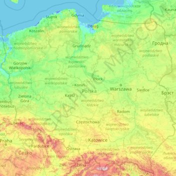
Name: Poland topographic map, elevation, terrain.
Location: Poland (49.00205 14.06964 55.03605 24.14578)
Average elevation: 194 m
Minimum elevation: -6 m
Maximum elevation: 2,237 m
Other topographic maps
Click on a map to view its topography, its elevation and its terrain.
Istanbul
Istanbul, located in northwestern Turkey, is a city that is uniquely situated across two continents, Europe and Asia, divided by the Bosphorus Strait. The city’s topography is characterized by a complex blend of hills, valleys, and coastal plains, which create a varied and scenic landscape. The European side…
Average elevation: 57 m
Chiang Mai
Chiang Mai has a tropical savanna climate (Köppen Aw), tempered by the low latitude and moderate elevation, with warm to hot weather year-round, though nighttime conditions during the dry season can be cool and much lower than daytime highs. The maximum temperature ever recorded was 42.4 °C (108.3 °F) in…
Average elevation: 424 m
Peterborough
United Kingdom > England > Cambridgeshire
The cathedral city of Ely is 24 miles (39 km) east-southeast across the Fens and the university city of Cambridge is 30 miles (48 km) to the southeast. The local topography is flat, and in places, the land lies below sea level.
Average elevation: 17 m
Bangladesh
With an elevation of 1,064 m (3,491 ft), Saka Haphong (also known as Mowdok Mual) near the border with Myanmar, is claimed to be the highest peak of Bangladesh. However, it is not yet widely recognized as the highest point of the country, and most sources give the honor to Keokradong.
Average elevation: 1,488 m
Balfour
Canada > British Columbia > Regional District of Central Kootenay > Area E (Balfour/Cottonwood Lake)
Average elevation: 673 m
Verdin
France > Bourgogne – Franche-Comté > Saône-et-Loire > Montagny-près-Louhans
Average elevation: 199 m
Ben Nevis
United Kingdom > Scotland > Highland
Ben Nevis has a highland tundra climate (ET in the Köppen classification). Ben Nevis's elevation, maritime location and topography frequently lead to cool and cloudy weather conditions, which can pose a danger to ill-equipped walkers. According to the observations carried out at the summit observatory from…
Average elevation: 912 m
Snowdon
United Kingdom > Wales > Gwynedd
Snowdon (/ˈsnoʊdən/), or Yr Wyddfa (Welsh: [ər ˈʊɨ̞̯ðva] ), is a mountain in Snowdonia in North Wales. It has an elevation of 1,085 metres (3,560 ft) above sea level, which makes it both the highest mountain in Wales and the highest in the British Isles south of the Scottish Highlands. Snowdon is…
Average elevation: 692 m
Cairn Gorm
United Kingdom > Scotland > Highland
Cairn Gorm (Scottish Gaelic: An Càrn Gorm) is a mountain in the Scottish Highlands. It is part of the Cairngorms range and wider Grampian Mountains. With a summit elevation of 1,245 m (4,085 ft) above sea level, Cairn Gorm is classed as a Munro and is the sixth-highest mountain in the British Isles. The high,…
Average elevation: 989 m
Ανδρούσα
Greece > Peloponnese, Western Greece and the Ionian > Messenia Regional Unit
Average elevation: 96 m
Vaal Dam
South Africa > Free State > Fezile Dabi District Municipality > Metsimaholo Local Municipality > Deneysville
Average elevation: 1,481 m
Tupungato
Chile > Santiago Metropolitan Region > Provincia de Cordillera > San José de Maipo
Average elevation: 6,002 m
Guadalajara
Mexico > Jalisco > Guadalajara
Under the Köppen climate classification, Guadalajara has a humid subtropical climate (Cwa), a temperate climate that is quite close to a tropical climate, featuring dry warm winters and wet, mildly hot summers. Guadalajara's climate is influenced by its high altitude and the general seasonality of…
Average elevation: 1,572 m
Southampton
United States > Pennsylvania > Bucks County > Upper Southampton Township
Average elevation: 75 m