
Thank you for supporting this site ❤️
Make a donation
Make a donation
Memel topographic map
Click on the map to display elevation.
Thank you for supporting this site ❤️
Make a donation
Make a donation
Memel
Memel-Zamani lies in the west-facing lee of the Drakensberg escarpment, the escarpment functioning as the continental divide. Its high elevation and close proximity to the escarpment are the major reason for Memel's cold winters. Visitors are frequently surprised by just how cold winter can be in Memel. Added to this is the fact that the town sits in a depression in the land, this depression being surrounded by distant mountains. Memel-Zamani lies near to the Klip River from where the towns water supply is drawn.
Thank you for supporting this site ❤️
Make a donation
Make a donation
About this map
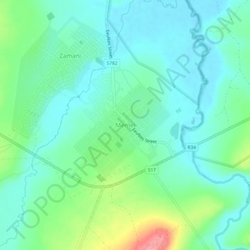
Name: Memel topographic map, elevation, terrain.
Average elevation: 1,723 m
Minimum elevation: 1,697 m
Maximum elevation: 1,800 m
Thank you for supporting this site ❤️
Make a donation
Make a donation