
Make a donation
Sunset Peak topographic map
Click on the map to display elevation.
Make a donation
Sunset Peak
Sunset Peak is only accessible by foot. It is located on section 2 of the 70 km (43 mi) long Lantau Trail. Section 2 is 6.5 km long and goes from Nam Shan Campsite west of Mui Wo on South Lantau Road (elevation about 120 m), to Pak Kung Au, another campsite on the Tung Chung Road (elevation about 340 m). Both campsites are served by a number of bus routes going to Mui Wo, Tung Chung, and other destinations on Lantau island.
Make a donation
About this map
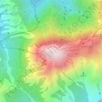
Name: Sunset Peak topographic map, elevation, terrain.
Average elevation: 411 m
Minimum elevation: 74 m
Maximum elevation: 856 m
Make a donation
Other topographic maps
Click on a map to view its topography, its elevation and its terrain.
Make a donation
Make a donation
Make a donation
Make a donation
Make a donation
Ma Wan
China > Hong Kong > Tsuen Wan District > Wang Lung Mei > Ma Wan Main Street Village
Average elevation: 12 m
Make a donation
Make a donation
Make a donation
Basalt Island
China > Hong Kong > Sai Kung District
Basalt Island is located south of Town Island and Wang Chau, east of Bluff Island and north of the Ninepin Group. Its highest elevation is 174 m. Notably, despite its name is “Basalt Island”, the rocks that forms the island are indeed rhyolitic tuff.
Average elevation: 6 m
Make a donation
Make a donation
Wu Kai Sha Beach
China > Hong Kong > Sha Tin District > Wu Kai Sha Village > Cheung Kang Village
Average elevation: 36 m
Make a donation
Kiu Tsui Country Park
China > Hong Kong > Sai Kung District > Sai Kung > Kiu Tsui
Average elevation: 4 m
Make a donation
Make a donation
Make a donation
Make a donation
Make a donation
Sheung Yat Chuen Fresh Water Tank
China > Hong Kong > Kwai Tsing District > Kwai Chung > Sheung Yat Tsuen
Average elevation: 179 m
Make a donation