
Make a donation
Hebei topographic map
Click on the map to display elevation.
Make a donation
Hebei
Hebei is the only province in China to contain plateaus, mountains, hills, shorelines, plains, and lakes. Most of central and southern Hebei lies within the North China Plain. Western Hebei rises into the Taihang Mountains (Taihang Shan), while the Yan Mountains (Yan Shan) runs through northern Hebei. Beyond the mountains are the grasslands of Inner Mongolia. The highest peak is Mount Xiaowutai in Yu County in the northwest of the province, with an altitude of 2,882 m (9,455 ft).
Make a donation
About this map
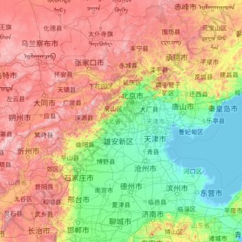
Name: Hebei topographic map, elevation, terrain.
Location: Hebei, China (36.04840 113.45647 42.61764 119.95285)
Average elevation: 677 m
Minimum elevation: -3 m
Maximum elevation: 3,029 m
Make a donation
Other topographic maps
Click on a map to view its topography, its elevation and its terrain.
Hong Kong
Hong Kong has a humid subtropical climate (Köppen Cwa), characteristic of southern China. Summer is hot and humid, with occasional showers and thunderstorms and warm air from the southwest. Typhoons occur most often then, sometimes resulting in floods or landslides. Winters are mild and usually sunny at the…
Average elevation: 62 m
Beijing
Beijing is situated at the northern tip of the roughly triangular North China Plain, which opens to the south and east of the city. Mountains to the north, northwest and west shield the city and northern China's agricultural heartland from the encroaching desert steppes. The northwestern part of the…
Average elevation: 47 m
Make a donation
Make a donation
Make a donation
Make a donation
Make a donation
Make a donation
Make a donation
Make a donation
Make a donation
Make a donation
Chongqing
The central urban area of Chongqing, or Chongqing proper, is a city of unique features. Built on mountains and partially surrounded by the Yangtze and Jialing rivers, it is known as a "mountain city" and a "city on rivers". The night scene of the city is very illuminated, with millions of lights and their…
Average elevation: 318 m
Make a donation
Jiuzhaigou
China > Sichuan > Jiuzhaigou County
The county consists of nine villages in a valley in Sichuan Province. The main ethnic group in the county is Han, with the second being Tibetan. The county seat has an altitude of about 1,400 m (4,600 ft). It has a total area of 2,041 square miles (5,286 km2). As of 2015, the county's total population was…
Average elevation: 2,520 m
Make a donation
Make a donation
Make a donation
Make a donation
Make a donation
Make a donation
Make a donation
Luen On San Tsuen
China > Hong Kong > Tuen Mun District > Tai Lam Chung Village
Average elevation: 54 m
Make a donation
Make a donation
Make a donation
Sam Mun Tsai
China > Hong Kong > Tai Po District > Shuen Wan Lei Uk > Sam Mun Tsai New Village
Average elevation: 9 m
Make a donation
Tseung Kwan O Waterfront Park
China > Hong Kong > Sai Kung District > Tseung Kwan O
Average elevation: 34 m
Hoi Pa Village South Terrace
China > Hong Kong > Tsuen Wan > Hoi Pa Village South Terrace
Average elevation: 140 m
Make a donation
Make a donation
Mount Everest
China > Tibet > Tingri County
Mount Everest (Nepali: सगरमाथा, romanized: Sagarmāthā; Tibetan: Chomolungma ཇོ་མོ་གླང་མ; Chinese: 珠穆朗玛峰; pinyin: Zhūmùlǎngmǎ Fēng) is Earth's highest mountain above sea level, located in the Mahalangur Himal sub-range of the Himalayas. The China–Nepal…
Average elevation: 7,851 m
Make a donation