
Make a donation
Guangyuan topographic map
Click on the map to display elevation.
Make a donation
About this map
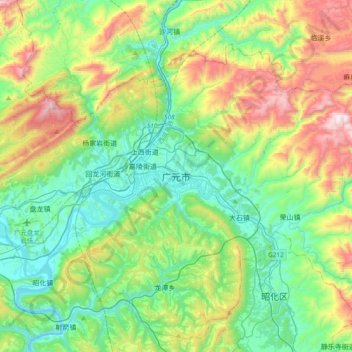
Name: Guangyuan topographic map, elevation, terrain.
Location: Guangyuan, Lizhou District, Guangyuan, Sichuan, China (32.27296 105.69634 32.59296 106.01634)
Average elevation: 805 m
Minimum elevation: 439 m
Maximum elevation: 1,676 m
Make a donation
Other topographic maps
Click on a map to view its topography, its elevation and its terrain.
Kangding
Kangding has a monsoon-influenced climate, lying in the transition between a humid continental (Dwb) and a subtropical highland climate (Cwb) on the Köppen system. Despite the elevation of 2,560 metres (8,400 ft), the diurnal temperature variation averages at most 10.6 °C (19.1 °F) in any month. From April…
Average elevation: 3,331 m
Make a donation
Daocheng County
Daocheng County or Dapba in Tibetan (Tibetan: འདབ་པ་རྫོང་།; Chinese: 稻城县) is a county of western Sichuan Province, China, located in the eastern Hengduan Mountains. It is under the administration of the Garzê Tibetan Autonomous Prefecture with an overwhelmingly Tibetan…
Average elevation: 3,926 m
Make a donation