
Thank you for supporting this site ❤️
Make a donation
Make a donation
Yongde topographic map
Click on the map to display elevation.
Thank you for supporting this site ❤️
Make a donation
Make a donation
About this map
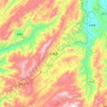
Name: Yongde topographic map, elevation, terrain.
Location: Yongde, Lincang, Yunnan, China (23.86769 99.09733 24.18769 99.41733)
Average elevation: 1,649 m
Minimum elevation: 763 m
Maximum elevation: 2,680 m
Thank you for supporting this site ❤️
Make a donation
Make a donation
Other topographic maps
Click on a map to view its topography, its elevation and its terrain.