
Tung Tsz topographic map
Interactive map
Click on the map to display elevation.
About this map
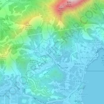
Name: Tung Tsz topographic map, elevation, terrain.
Location: Tung Tsz, New Territories, Hong Kong, China (22.47209 114.19947 22.47319 114.20083)
Average elevation: 102 m
Minimum elevation: -2 m
Maximum elevation: 479 m
Other topographic maps
Click on a map to view its topography, its elevation and its terrain.
Yim Tin Tsai
China > Hong Kong > Tai Po District > Shuen Wan Lei Uk > Sam Mun Tsai New Village
Average elevation: 3 m
Luen On San Tsuen
China > Hong Kong > Tuen Mun District > Tai Lam Chung Village
Average elevation: 54 m
Cheung Po Tsai Cave
China > Hong Kong > Islands District > 應善良美經援村 Ying Sin Leung Care Village
Average elevation: 2 m
Sam Mun Tsai
China > Hong Kong > Tai Po District > Shuen Wan Lei Uk > Sam Mun Tsai New Village
Average elevation: 9 m
Luen On San Tsuen
China > Hong Kong > Tuen Mun District > Tai Lam Chung Village
Average elevation: 54 m
Tai Mo Shan
China > Hong Kong > Tsuen Wan District
Tai Mo Shan is the highest peak in Hong Kong, with an elevation of 957 metres (3,140 ft) above the Hong Kong Principal Datum [zh-tw], or around 956 metres (3,136 ft) above mean sea level. It is located at approximately the geographical centre of the New Territories.
Average elevation: 600 m
Hoi Pa Village South Terrace
China > Hong Kong > Tsuen Wan > Hoi Pa Village South Terrace
Average elevation: 140 m