
Thank you for supporting this site ❤️
Make a donation
Make a donation
Liaoyang topographic map
Click on the map to display elevation.
Thank you for supporting this site ❤️
Make a donation
Make a donation
About this map
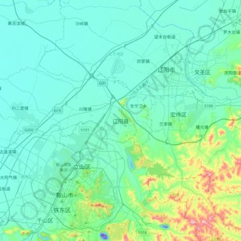
Name: Liaoyang topographic map, elevation, terrain.
Location: Liaoyang, Liaoyang City, Liaoning, 111000, China (41.04554 122.92897 41.36554 123.24897)
Average elevation: 59 m
Minimum elevation: -60 m
Maximum elevation: 405 m
Thank you for supporting this site ❤️
Make a donation
Make a donation
Other topographic maps
Click on a map to view its topography, its elevation and its terrain.
Anshan City
Local transportation is primarily by bus or taxi. Anshan used to have a single tram line—along Zhonghua Avenue, through the city centre and past Angang main gate—but this has been closed and the tracks removed. Due to the flat topography of the city centre, bicycles are popular. Almost all roads have a…
Average elevation: 145 m
Thank you for supporting this site ❤️
Make a donation
Make a donation