
枣庄市 topographic map
Interactive map
Click on the map to display elevation.
About this map
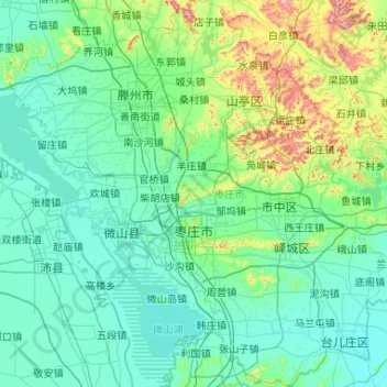
Name: 枣庄市 topographic map, elevation, terrain.
Location: 枣庄市, 山东省, 中国 (34.46237 116.80497 35.32174 117.83048)
Average elevation: 97 m
Minimum elevation: 22 m
Maximum elevation: 636 m
Other topographic maps
Click on a map to view its topography, its elevation and its terrain.
昌邑市城市规划技术服务中心潍河西开放式养殖项目
昌邑市城市规划技术服务中心潍河西开放式养殖项目, 昌邑市, 潍坊市, 山东省, 中国
Average elevation: 0 m