
潍坊市 topographic map
Interactive map
Click on the map to display elevation.
About this map
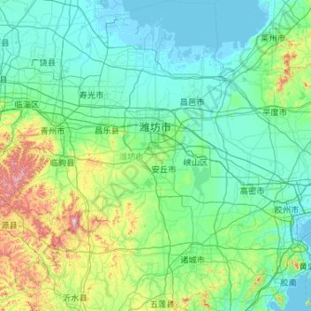
Name: 潍坊市 topographic map, elevation, terrain.
Location: 潍坊市, 山东省, 中国 (35.71638 118.17028 37.37234 120.01012)
Average elevation: 101 m
Minimum elevation: -3 m
Maximum elevation: 964 m
Other topographic maps
Click on a map to view its topography, its elevation and its terrain.
昌邑市城市规划技术服务中心潍河西开放式养殖项目
昌邑市城市规划技术服务中心潍河西开放式养殖项目, 昌邑市, 潍坊市, 山东省, 中国
Average elevation: 0 m