
芝罘区 topographic map
Interactive map
Click on the map to display elevation.
About this map
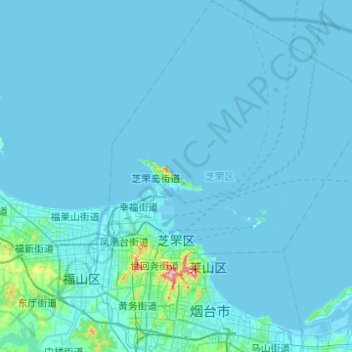
Name: 芝罘区 topographic map, elevation, terrain.
Location: 芝罘区, 烟台市, 山东省, 264000, 中国 (37.41456 121.27538 37.80577 121.67635)
Average elevation: 11 m
Minimum elevation: -3 m
Maximum elevation: 377 m
Other topographic maps
Click on a map to view its topography, its elevation and its terrain.
昌邑市城市规划技术服务中心潍河西开放式养殖项目
昌邑市城市规划技术服务中心潍河西开放式养殖项目, 昌邑市, 潍坊市, 山东省, 中国
Average elevation: 0 m