
Make a donation
Netherlands topographic map
Click on the map to display elevation.
Make a donation
About this map
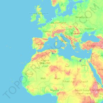
Name: Netherlands topographic map, elevation, terrain.
Location: Netherlands (11.77700 -70.26959 53.74440 7.22750)
Average elevation: 252 m
Minimum elevation: -7 m
Maximum elevation: 4,026 m
Make a donation
Other topographic maps
Click on a map to view its topography, its elevation and its terrain.
Istanbul
Istanbul, located in northwestern Turkey, is a city that is uniquely situated across two continents, Europe and Asia, divided by the Bosphorus Strait. The city’s topography is characterized by a complex blend of hills, valleys, and coastal plains, which create a varied and scenic landscape. The European side…
Average elevation: 57 m
Bangladesh
With an elevation of 1,064 m (3,491 ft), Saka Haphong (also known as Mowdok Mual) near the border with Myanmar, is claimed to be the highest peak of Bangladesh. However, it is not yet widely recognized as the highest point of the country, and most sources give the honor to Keokradong.
Average elevation: 1,488 m
Chiang Mai
Chiang Mai has a tropical savanna climate (Köppen Aw), tempered by the low latitude and moderate elevation, with warm to hot weather year-round, though nighttime conditions during the dry season can be cool and much lower than daytime highs. The maximum temperature ever recorded was 42.4 °C (108.3 °F) in…
Average elevation: 424 m
Make a donation
Make a donation
Hong Kong
Hong Kong has a humid subtropical climate (Köppen Cwa), characteristic of southern China. Summer is hot and humid, with occasional showers and thunderstorms and warm air from the southwest. Typhoons occur most often then, sometimes resulting in floods or landslides. Winters are mild and usually sunny at the…
Average elevation: 62 m
Make a donation
Međugorje
Bosnia and Herzegovina > Federation of Bosnia and Herzegovina
The name Međugorje literally means "between mountains". At an altitude of 200 m (660 ft) above sea level it has a mild Mediterranean climate. The town consists of an ethnically homogeneous Croat population of 2,306. The Catholic parish includes four neighbouring villages: Bijakovići, Vionica, Miletina and…
Average elevation: 203 m
Europe
Europe's topography is characterized by a striking contrast between its rugged southern mountains and the expansive plains of the north. The continent is often described as a "peninsula of peninsulas," featuring major peninsulas like the Iberian, Italian, and Balkan, each with unique geological features. In…
Average elevation: 223 m
Wonderkop Nature Reserve
South Africa > Limpopo > Capricorn District Municipality
Average elevation: 904 m
Make a donation
Hoodoo Mountain
Canada > British Columbia > Regional District of Kitimat-Stikine > Area D (Iskut/Big Raven)
Hoodoo Mountain, sometimes referred to as Hoodoo Volcano, is a potentially active stratovolcano in the Northern Interior of British Columbia, Canada. It is located 25 kilometres (16 miles) northeast of the Alaska–British Columbia border on the north side of the Iskut River opposite of the mouth of the Craig…
Average elevation: 1,657 m
Make a donation
Make a donation
Make a donation
Kastelli
Greece > Region of Crete > Heraklion Regional Unit > Kastelli Municipal Unit
Average elevation: 366 m
Make a donation
Make a donation
Make a donation
Make a donation
Make a donation
Aberlour
United Kingdom > Scotland > Moray
According to the 1846 A Topographical Dictionary of Scotland, "This parish, formerly called Skirdustan, signifying, in the Gaelic tongue, 'the division of Dustan', its tutelary saint, derived its present name from its situation at the mouth of a noisy burn, which discharges itself into the river Spey."
Average elevation: 160 m
Holeta Genet
Ethiopia > Oromia Region > Walmara
Holeta (Amharic: ሆለታ) (Oromo: Holataa) is a town in the special zone of Oromia Region, Ethiopia. It has a latitude and longitude of 9°3′N 38°30′E / 9.050°N 38.500°E / 9.050; 38.500 and an altitude of 2391 meters above sea level.
Average elevation: 2,391 m
Make a donation
Make a donation
Make a donation
Make a donation
Maseru
Maseru is located in northwest Lesotho by the South African border, denoted by the Mohokare River, also known as Caledon River. The two countries are connected by a border post at the Maseru Bridge, which crosses the river. On the South African side, Ladybrand is the town closest to Maseru. The city lies in a…
Average elevation: 1,606 m
Featherston
New Zealand > Wellington > South Wairarapa District > Featherston Community
Average elevation: 125 m
Make a donation
Make a donation
Make a donation
Make a donation
Make a donation
Andes
Andes is a municipality and town in the Antioquia Department, Colombia. Part of the sub-region of Southwestern Antioquia, it is located on the western Colombian Andes mountain range. Andes was founded on 13 March 1852 by Pedro Antonio Restrepo Escobar. Its elevation is 1,360 metres above sea level with an…
Average elevation: 1,559 m
Make a donation
Cajon Pass
United States > California > San Bernardino County
Cajon Pass (/kəˈhoʊn/; Spanish: Puerto del Cajón or Paso del Cajón) is a mountain pass between the San Bernardino Mountains to the east and the San Gabriel Mountains to the west in Southern California. Created by the movements of the San Andreas Fault, it has an elevation of 3,777 ft (1,151 m). Located in…
Average elevation: 1,169 m
Rangamati
Bangladesh > Chattogram Division > Rangamati Sadar Upazila
Rangamati (Bengali: রাঙামাটি) is a town and the administrative headquarters of Rangamati District in the Chittagong Hill Tracts of Bangladesh. The town is located at 22°37'60N 92°12'0E and has an elevation of 14 metres (46 ft) above sea level.
Average elevation: 68 m
Make a donation
Make a donation
Mount Royal
Canada > Quebec > Urban agglomeration of Montreal > Montreal
The mountain is part of the Monteregian Hills situated between the Laurentians and the Appalachian Mountains. It gave its Latin name, Mons Regius, to the Monteregian chain. The mountain consists of three peaks: Colline de la Croix (or Mont Royal proper) at 233 m (764 ft), Colline d'Outremont (or Mount Murray,…
Average elevation: 111 m
Make a donation