
Međugorje topographic map
Interactive map
Click on the map to display elevation.
About this map
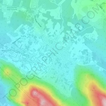
Name: Međugorje topographic map, elevation, terrain.
Average elevation: 203 m
Minimum elevation: 136 m
Maximum elevation: 460 m
The name Međugorje literally means "between mountains". At an altitude of 200 m (660 ft) above sea level it has a mild Mediterranean climate. The town consists of an ethnically homogeneous Croat population of 2,306. The Catholic parish includes four neighbouring villages: Bijakovići, Vionica, Miletina and Šurmanci. Since 2019, pilgrimages to Medjugorje have been authorized by the Vatican as long as there is no assumption the events are confirmed to have a supernatural origin.
Other topographic maps
Click on a map to view its topography, its elevation and its terrain.
Tuzla
Bosnia and Herzegovina > Federation of Bosnia and Herzegovina > City of Tuzla > Tuzla
Tuzla, City of Tuzla, Tuzla Canton, Federation of Bosnia and Herzegovina, 75000, Bosnia and Herzegovina
Average elevation: 349 m
Canton 10
Bosnia and Herzegovina > Federation of Bosnia and Herzegovina
Canton 10, Federation of Bosnia and Herzegovina, Bosnia and Herzegovina
Average elevation: 931 m