
三台县 topographic map
Interactive map
Click on the map to display elevation.
About this map
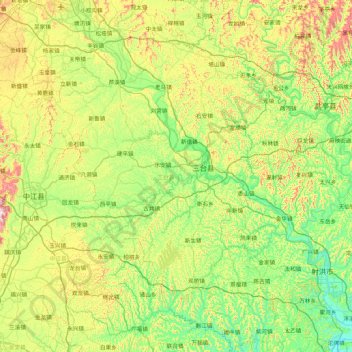
Name: 三台县 topographic map, elevation, terrain.
Location: 三台县, 绵阳市, 四川省, 中国 (30.70816 104.71161 31.44435 105.29761)
Average elevation: 453 m
Minimum elevation: 300 m
Maximum elevation: 814 m
三台属川中丘陵地区,地势北高南低,由北向南倾斜。平均海拔450米左右,最高点龙树镇西北博。达岭海拔672米,最低点建中乡。江河边短沟口海拔307.2米。以丘陵为主,丘陵面积占幅员面积94.3%,平坝河谷面积占5.7%;有耕地面积83029公顷,农业人均耕地0.95亩;有水域9782公顷,森林69700公顷。山丘起伏,沟壑纵横,梯地层迭,林果粮间长,多种经营具有广阔发展前景。
Other topographic maps
Click on a map to view its topography, its elevation and its terrain.