
盐亭县 topographic map
Interactive map
Click on the map to display elevation.
About this map
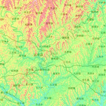
Name: 盐亭县 topographic map, elevation, terrain.
Location: 盐亭县, 绵阳市, 四川省, 中国 (30.97484 105.20207 31.48848 105.72184)
Average elevation: 460 m
Minimum elevation: 336 m
Maximum elevation: 759 m
盐亭位于四川盆地西北,属丘陵地区,地势南低北高,海拔350-650米;属亚热带湿润季风气候,年平均气温17℃,年降雨量907毫米,全年无霜期294天。
Other topographic maps
Click on a map to view its topography, its elevation and its terrain.