Great Britain topographic map
Click on the map to display elevation.
Great Britain
Great Britain's topography is characterized by a diverse landscape shaped by its geological history. The island predominantly features lowland terrain in the east and south, with rolling countryside and plains, while the western and northern regions are marked by hills and mountains. Notable upland areas include the Lake District and the Pennines in England, the Grampian Mountains in Scotland, and the Cambrian Mountains in Wales. The highest peak, Ben Nevis in Scotland, rises to 1,345 meters (4,413 feet). The terrain also showcases features such as the White Cliffs of Dover, composed of chalk and flint, and the rugged landscapes formed by glacial activity during the last ice age.
About this map
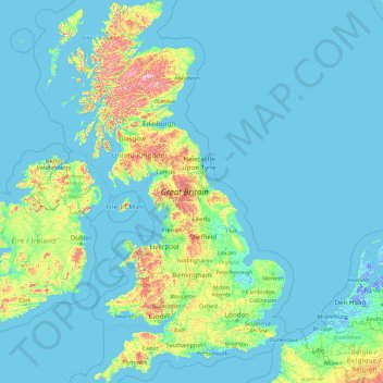
Name: Great Britain topographic map, elevation, terrain.
Location: Great Britain, United Kingdom (49.95870 -6.22788 58.67208 1.76322)
Average elevation: 52 m
Minimum elevation: -6 m
Maximum elevation: 1,233 m
Other topographic maps
Click on a map to view its topography, its elevation and its terrain.
Sutton
United Kingdom > England > London
Elevations in and around the town range from 115 metres (377 ft) AOD in Belmont to 23 metres (75 ft) in Sutton Common, at the start of the Pyl Brook stream.
Average elevation: 63 m
Scottish Highlands
United Kingdom > Scotland > Highland
The entire region was covered by ice sheets during the Pleistocene ice ages, save perhaps for a few nunataks. The complex geomorphology includes incised valleys and lochs carved by the action of mountain streams and ice, and a topography of irregularly distributed mountains whose summits have similar heights…
Average elevation: 907 m
Oakthorpe
United Kingdom > England > Leicestershire > North West Leicestershire
Average elevation: 94 m

South Ascot
United Kingdom > England > Royal Borough of Windsor and Maidenhead > South Ascot
Average elevation: 74 m
Malvern
United Kingdom > England > Worcestershire > Malvern Hills
Malvern lies in the Lower Severn/Avon plain affording it a degree of shelter caused by virtue of its nestling in between the Cotswold hills to the east, the Welsh Hills and Mountains to the west, and Birmingham plateau to the north. Although as with all the British Isles it has a maritime climate, the local…
Average elevation: 95 m
Glasgow
United Kingdom > Scotland > Glasgow City
Glasgow itself was reputed to have been founded by the Christian missionary Saint Mungo in the 6th century. He established a church on the Molendinar Burn, where the present Glasgow Cathedral stands, and in the following years Glasgow became a religious centre. Glasgow grew over the following centuries as part…
Average elevation: 128 m

Swansea
United Kingdom > Wales > Swansea
Much of Swansea is hilly with the main area of upland being located in the council ward of Mawr. Areas up to 185 metres (607 ft) in elevation range across the central section: Kilvey Hill, Townhill and Llwynmawr separate the centre of Swansea from its northern suburbs. Cefn Bryn, a ridge of high land, is the…
Average elevation: 73 m
Berry Island
United Kingdom > England > Westmorland and Furness > Low Wood > High Brow Edge
Average elevation: 68 m

Stow-on-the-Wold
United Kingdom > England > Gloucestershire > Cotswold District > Stow-on-the-Wold
Average elevation: 163 m