
Thank you for supporting this site ❤️
Make a donation
Make a donation
Trellech topographic map
Click on the map to display elevation.
Thank you for supporting this site ❤️
Make a donation
Make a donation
About this map
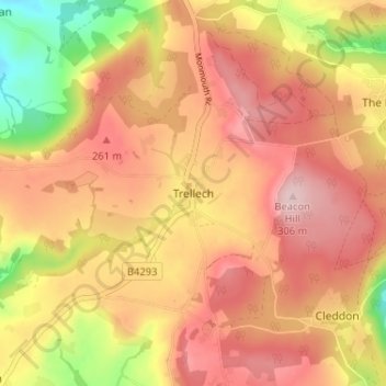
Name: Trellech topographic map, elevation, terrain.
Location: Trellech, Monmouthshire, Wales, NP25 4NY, United Kingdom (51.72509 -2.74445 51.76509 -2.70445)
Average elevation: 217 m
Minimum elevation: 79 m
Maximum elevation: 303 m
Thank you for supporting this site ❤️
Make a donation
Make a donation