
Turkey topographic map
Click on the map to display elevation.
Turkey
Turkey's topography is a diverse tapestry of mountains, plateaus, and coastal plains that create a strikingly varied landscape. The country is predominantly characterized by the Anatolian Plateau, a semi-arid highland that stretches across central Turkey, with elevations ranging from 700 to 2,000 meters. This plateau is flanked by the Pontic Mountains to the north and the Taurus Mountains to the south, both of which run parallel to the respective coastlines. In the east, the terrain becomes more rugged and elevated, culminating in Mount Ararat, Turkey's highest peak at 5,137 meters. Coastal regions, such as the Aegean and Mediterranean shores, feature narrow plains that give way to rolling hills and steep mountains, while the Black Sea coast is lined with dense forests and receives the highest precipitation in the country. This complex terrain not only shapes Turkey's diverse climates and ecosystems but also influences human activities, from agriculture in the fertile basins to tourism in the picturesque valleys and mountains.
About this map
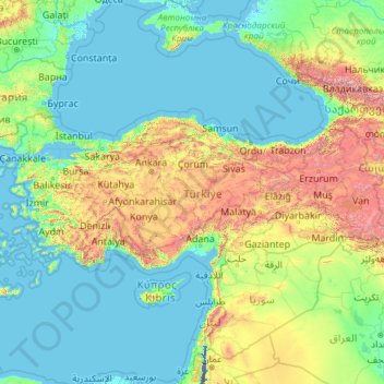
Name: Turkey topographic map, elevation, terrain.
Location: Turkey (35.80590 25.56563 42.29700 44.81766)
Average elevation: 487 m
Minimum elevation: -415 m
Maximum elevation: 5,225 m
Other topographic maps
Click on a map to view its topography, its elevation and its terrain.
Istanbul
Istanbul, located in northwestern Turkey, is a city that is uniquely situated across two continents, Europe and Asia, divided by the Bosphorus Strait. The city’s topography is characterized by a complex blend of hills, valleys, and coastal plains, which create a varied and scenic landscape. The European side…
Average elevation: 57 m
Chiang Mai
Chiang Mai has a tropical savanna climate (Köppen Aw), tempered by the low latitude and moderate elevation, with warm to hot weather year-round, though nighttime conditions during the dry season can be cool and much lower than daytime highs. The maximum temperature ever recorded was 42.4 °C (108.3 °F) in…
Average elevation: 424 m
Hong Kong
Hong Kong has a humid subtropical climate (Köppen Cwa), characteristic of southern China. Summer is hot and humid, with occasional showers and thunderstorms and warm air from the southwest. Typhoons occur most often then, sometimes resulting in floods or landslides. Winters are mild and usually sunny at the…
Average elevation: 62 m
Golan Heights
In addition to the city of Golan (Γαυλάνην), Flavius Josephus describes "Gaulanitis" (Γαυλανῖτις), a territory containing the towns of Gamla (or Jamla) and Bethsaida in its "Lower" part, Sogane (Σωγανή, possibly Khirbet Sujan or Sakhnin) in its "Upper" part, and also Solyma…
Average elevation: 406 m
Bangladesh
With an elevation of 1,064 m (3,491 ft), Saka Haphong (also known as Mowdok Mual) near the border with Myanmar, is claimed to be the highest peak of Bangladesh. However, it is not yet widely recognized as the highest point of the country, and most sources give the honor to Keokradong.
Average elevation: 1,488 m
Ankara
Ankara has a cold semi-arid climate (Köppen climate classification: BSk). Under the Trewartha climate classification, Ankara has a temperate humid continental climate (Dc). Due to its elevation and inland location, Ankara has cold and snowy winters, and hot and dry summers. Rainfall occurs mostly during the…
Average elevation: 1,082 m
Cajon Pass
United States > California > San Bernardino County
Cajon Pass (/kəˈhoʊn/; Spanish: Puerto del Cajón or Paso del Cajón) is a mountain pass between the San Bernardino Mountains to the east and the San Gabriel Mountains to the west in Southern California. Created by the movements of the San Andreas Fault, it has an elevation of 3,777 ft (1,151 m). Located in…
Average elevation: 1,169 m
Chania
Greece > Region of Crete > Chania Regional Unit
The climate in Chania is further complemented due to the terrain and can vary throughout its regions and elevations and according to its topography. At the south lies the mountain range of Lefka Ori. Furthermore, prevailing winds, such as those of the West side and South of Crete, in addition to the North…
Average elevation: 194 m
Vila Soeiro do Chão
Portugal > Guarda > Juncais, Vila Ruiva e Vila Soeiro do Chão
Average elevation: 439 m
Valtuille de Abajo
Spain > Castile and León > El Bierzo > Villafranca del Bierzo
Average elevation: 525 m
Great Wall Station
The station is about 2.5 kilometres (1.6 mi) from the Chilean Base Presidente Eduardo Frei Montalva. A 3 kilometres (1.9 mi) long unpaved road, Zhongzhi Gonglu, provides convenient vehicle access from the station to Frei, Teniente Rodolfo Marsh Martin Airport and Bellingshausen Station. The station…
Average elevation: 14 m
Skardu
Pakistan > Gilgit-Baltistan > Skardu District
Skardu (Urdu: سکردو, romanised: skardū, Tibetan script: སྐར་མདོ, pronounced [skərduː]) is a city located in Pakistan-administered Gilgit-Baltistan in the disputed Kashmir region. Skardu serves as the capital of Skardu District and the Baltistan Division. It is situated at an average…
Average elevation: 3,423 m
Shiyan
The far northern and southern reaches of Shiyan are the highest in elevation, while the geographic center of the city has a relatively low elevation. The highest point in Shiyan is Congping in Zhuxi County, at 2,740.2 metres (8,990 ft) above sea level, while the lowest point, Panjiayan in Danjiangkou, is 87…
Average elevation: 422 m
Molave
Philippines > Zamboanga del Sur
Molave is divided into two topographical areas. The east and southwest lowlands, which cover 30 percent of its total land area, consist of nine barangays and are generally flat, swampy and marshy. The upland, which covers 70 percent of Molave's total area, is hilly and mostly deforested. The terrain is…
Average elevation: 41 m
Međugorje
Bosnia and Herzegovina > Federation of Bosnia and Herzegovina
The name Međugorje literally means "between mountains". At an altitude of 200 m (660 ft) above sea level it has a mild Mediterranean climate. The town consists of an ethnically homogeneous Croat population of 2,306. The Catholic parish includes four neighbouring villages: Bijakovići, Vionica, Miletina and…
Average elevation: 203 m
Africa
Average elevation: 462 m
Toconao
Chile > Antofagasta Region > Provincia de El Loa > San Pedro de Atacama
Toconao is a village 38 km (24 mi) south of San Pedro de Atacama in the San Pedro de Atacama province of Chile's northern Antofagasta Region. It lies at an elevation of 2,485 m (8,153 ft) above sea level, close to the northeast margin of the Salar de Atacama.
Average elevation: 2,488 m
Doi Suthep
Doi Suthep (ดอยสุเทพ), is a mountain ("doi") west of Chiang Mai, Thailand. It is 1,676 metres (5,499 ft) in elevation and is one of the twin peaks of a granite mountain. The other peak is known as Doi Pui and is slightly higher (1,685 metres (5,528 ft)).
Average elevation: 1,351 m
Matsulu
South Africa > Mpumalanga > Ehlanzeni District Municipality > Mbombela
Average elevation: 449 m
Mount Apo
Philippines > Davao del Sur > Bansalan
Mount Apo is the highest mountain peak in the Philippines, with an elevation of 2,954 meters (9,692 ft) above sea level. A large solfataric, dormant stratovolcano, it is part of the Apo-Talomo Mountain Range of Mindanao island. Apo is situated on the tripartite border of Davao City, Davao del Sur, and…
Average elevation: 2,416 m
Sutton
United Kingdom > England > London
Elevations in and around the town range from 115 metres (377 ft) AOD in Belmont to 23 metres (75 ft) in Sutton Common, at the start of the Pyl Brook stream.
Average elevation: 63 m
Balfour
Canada > British Columbia > Regional District of Central Kootenay > Area E (Balfour/Cottonwood Lake)
Average elevation: 673 m