
Make a donation
Bozhou topographic map
Click on the map to display elevation.
Make a donation
About this map
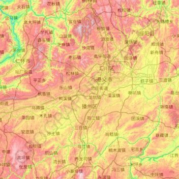
Name: Bozhou topographic map, elevation, terrain.
Location: Bozhou, Zunyi, Guizhou, China (27.22094 106.29987 28.03855 107.43922)
Average elevation: 995 m
Minimum elevation: 380 m
Maximum elevation: 1,806 m
Make a donation
Other topographic maps
Click on a map to view its topography, its elevation and its terrain.
Fanjing Mountain
China > Guizhou > Yinjiang Tujia and Miao Autonomous County
The Fanjingshan (Chinese: 梵净山; pinyin: Fànjìngshān) or Mount Fanjing, located in Tongren, Guizhou province, is the highest peak of the Wuling Mountains in southeastern China, at an elevation of 2,570 m (8,430 ft). The Fanjingshan National Nature Reserve was established in 1978 and designated a UNESCO…
Average elevation: 2,054 m
Make a donation
Make a donation
Make a donation
Make a donation
Make a donation
Make a donation
Fanjingshan
The Fanjingshan (Chinese: 梵净山; pinyin: Fànjìngshān) or Mount Fanjing, located in Tongren, Guizhou province, is the highest peak of the Wuling Mountains in southwestern China, at an elevation of 2,570 m (8,430 ft). The Fanjingshan National Nature Reserve was established in 1978 and designated a UNESCO…
Average elevation: 1,958 m
Shandong
China > Guizhou > Qiandongnan Miao and Dong Autonomous Prefecture > Shandong
Average elevation: 1,000 m
Make a donation
Yinjiang
China > Guizhou > Yinjiang Tujia and Miao Autonomous County > Yinjiang
Average elevation: 787 m
Bijie
Bijie borders Zunyi to the east, Anshun and Liupanshui to the south, Zhaotong and Qujing (Yunnan) to the west, and Luzhou (Sichuan) to the north. It spans latitude 26°21′−27°46′ N and longitude 105°36′−106°43′ E, and is marked heavily by the presence of the Wumeng Mountains (乌蒙山) as well…
Average elevation: 1,651 m
Make a donation