
Make a donation
Sivas Belediyesi topographic map
Click on the map to display elevation.
Make a donation
Sivas Belediyesi
The city, which lies at an elevation of 1,278 metres (4,193 ft) in the broad valley of the Kızılırmak river, is a moderately sized trade centre and industrial city, although the economy has traditionally been based on agriculture. Rail repair shops and a thriving manufacturing industry of rugs, bricks, cement, and cotton and woolen textiles form the mainstays of the city's economy. The surrounding region is a cereal-producing area with large deposits of iron ore which are worked at Divriği.
Make a donation
About this map
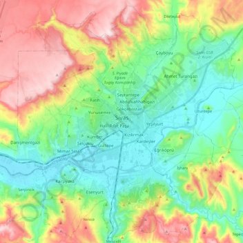
Name: Sivas Belediyesi topographic map, elevation, terrain.
Location: Sivas Belediyesi, Sivas, Central Anatolia Region, Turkey (39.66770 36.89967 39.82706 37.11641)
Average elevation: 1,399 m
Minimum elevation: 1,250 m
Maximum elevation: 1,669 m
Make a donation
Other topographic maps
Click on a map to view its topography, its elevation and its terrain.