
Make a donation
Agoo topographic map
Click on the map to display elevation.
Make a donation
Agoo
The town's topography is characterized by hilly and mountainous terrain that rises gradually eastward from the coastal plains. Its landscape is also marked by wetlands, scrublands, and grasslands. Mount Katayagan, the highest peak in the town, provides a watershed that supplies water for irrigation and households, and is home to biodiversity, including a closed forest with secondary-growth tropical moist deciduous forest.
Make a donation
About this map
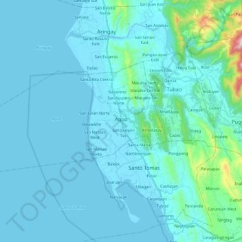
Name: Agoo topographic map, elevation, terrain.
Location: Agoo, La Union, Ilocos Region, Philippines (16.27155 120.19856 16.36995 120.40644)
Average elevation: 57 m
Minimum elevation: -1 m
Maximum elevation: 688 m
Make a donation
Other topographic maps
Click on a map to view its topography, its elevation and its terrain.
Naguilian
The approximate elevation of the municipality is 165 meters above sea level. It has the ninth highest approximate average elevation among the twenty (20) towns of the province. The portion with the highest elevation is 544 meters above sea level while the lowest is 10 meters. The slopes range from 2–7% in…
Average elevation: 85 m
Make a donation
Bacnotan
The topography of the town is characterized by hilly and mountainous terrain rising gradually eastward. The western side of Bacnotan is defined by a long stretch of black sand beaches facing the South China Sea, indicative of the area's abundant magnetite deposits. Certain parts of the coastline also feature…
Average elevation: 21 m
Make a donation
Make a donation
Make a donation
Make a donation
San Juan
The topography of the town is characterized by hilly and mountainous terrain that gradually rises eastward from its coastal plains along the foothills of the Cordillera Central. The town is also traversed by several creeks and rivers, with the Baroro River being the most prominent.
Average elevation: 21 m
Make a donation
Make a donation
Make a donation
San Gabriel
The Municipality of San Gabriel is recognized as the largest municipality by land area in La Union. The town’s topography is predominantly mountainous, gradually ascending eastward, with a mix of scrubland, grassland, and wetland ecosystems. Its landscape is traversed by the Baroro River, the town's major…
Average elevation: 131 m
Make a donation
Agoo-Damortis Protected Landscape and Seascape
Philippines > La Union > Santo Tomas
Average elevation: 9 m
Make a donation
Make a donation
Make a donation
Make a donation
Make a donation
Make a donation
Make a donation
Make a donation
Make a donation
Make a donation
Make a donation
Make a donation
Make a donation
Make a donation
Make a donation
Make a donation