
Hubei topographic map
Interactive map
Click on the map to display elevation.
About this map
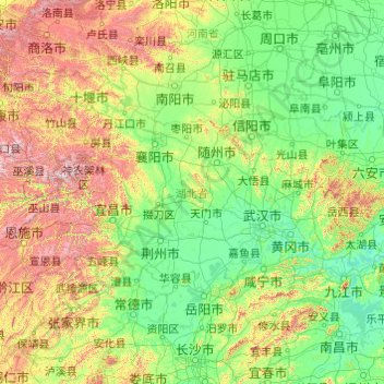
Name: Hubei topographic map, elevation, terrain.
Location: Hubei, China (29.03293 108.36257 33.27277 116.13218)
Average elevation: 363 m
Minimum elevation: 6 m
Maximum elevation: 2,922 m
Other topographic maps
Click on a map to view its topography, its elevation and its terrain.
Yunnan
Yunnan is situated in a mountainous area, with high elevations in the Northwest and low elevations in the Southeast. Most of the population lives in the eastern part of the province. In the west, the altitude can vary from the mountain peaks to river valleys as much as 3,000 m (9,800 ft). Yunnan is rich in…
Average elevation: 1,713 m
Kangding
Kangding has a monsoon-influenced climate, lying in the transition between a humid continental (Dwb) and a subtropical highland climate (Cwb) on the Köppen system. Despite the elevation of 2,560 metres (8,400 ft), the diurnal temperature variation averages at most 10.6 °C (19.1 °F) in any month. From April…
Average elevation: 3,331 m
Aksay Kazakh Autonomous County
The county lies on the northern edge of the Tibetan Plateau and has an average elevation of about 3,200 meters.
Average elevation: 2,661 m
Mount Everest
China > Tibet > Tingri County
Mount Everest (also Mount Sagarmatha or Mount Qomolangma) is Earth's highest mountain above sea level, located in the Mahalangur Himal sub-range of the Himalayas. The China–Nepal border runs across its summit point. Its elevation (snow height) of 8,848.86 m (29,031 ft 8+1⁄2 in) was most recently…
Average elevation: 7,847 m
Hainan Province
Even while Hainan Island was a part of Guangdong it had a considerable amount of local autonomy; the southern half of the island was an autonomous prefecture. Hainan's elevation to provincial level in 1988 increased its accountability to the Central People's Government, but by designating the new province a…
Average elevation: 95 m
Anhui
Anhui is topographically diverse. The north is part of the North China Plain while the north-central areas are part of the Huai River watershed. Both regions are flat, and densely populated. The land becomes more uneven further south, with the Dabie Mountains occupying much of southwestern Anhui and a series…
Average elevation: 99 m
Inner Mongolia
Inner Mongolia largely consists of the northern side of the North China Craton, a tilted and sedimented Precambrian block. In the extreme southwest is the edge of the Tibetan Plateau where the autonomous region's highest peak, Main Peak in the Helan Mountains reaches 3,556 metres (11,670 ft), and is still…
Average elevation: 891 m
Jiangsu
Jiangsu is flat, with plains covering 68 percent of its total area (water covers another 18 percent). Most of the province stands not more than 50 meters (160 ft) above sea level. Jiangsu also has a well-developed irrigation system, which earned it (especially the southern half) the moniker of traditional…
Average elevation: 24 m