
Thank you for supporting this site ❤️
Make a donation
Make a donation
Dalian City topographic map
Click on the map to display elevation.
Thank you for supporting this site ❤️
Make a donation
Make a donation
About this map
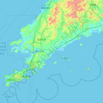
Name: Dalian City topographic map, elevation, terrain.
Location: Dalian City, Liaoning, China (38.57183 120.97190 40.20400 123.51525)
Average elevation: 46 m
Minimum elevation: -2 m
Maximum elevation: 1,027 m
Thank you for supporting this site ❤️
Make a donation
Make a donation
Other topographic maps
Click on a map to view its topography, its elevation and its terrain.