
So Kwun Po Village topographic map
Interactive map
Click on the map to display elevation.
About this map
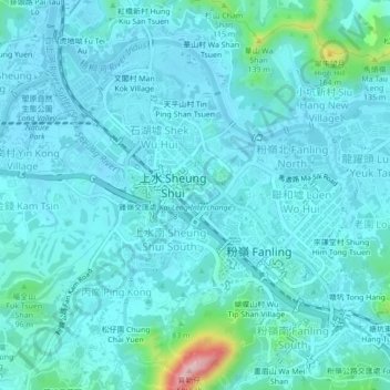
Name: So Kwun Po Village topographic map, elevation, terrain.
Average elevation: 27 m
Minimum elevation: -2 m
Maximum elevation: 228 m
Other topographic maps
Click on a map to view its topography, its elevation and its terrain.
Sha Tau Kok
China > Hong Kong > North District
Sha Tau Kok, North District, New Territories, Hong Kong, China
Average elevation: 138 m
Kat O Fisherman Village
China > Hong Kong > North District
Kat O Fisherman Village, North District, New Territories, Hong Kong, China
Average elevation: 3 m