
Make a donation
Myanmar topographic map
Click on the map to display elevation.
Make a donation
Myanmar
In the north, the Hengduan Mountains form the border with China. Hkakabo Razi, located in Kachin State, at an elevation of 5,881 metres (19,295 ft), is the highest point in Myanmar. Many mountain ranges, such as the Rakhine Yoma, the Bago Yoma, the Shan Hills and the Tenasserim Hills exist within Myanmar, all of which run north-to-south from the Himalayas. The mountain chains divide Myanmar's three river systems, which are the Irrawaddy, Salween (Thanlwin), and the Sittaung rivers. The Irrawaddy River, Myanmar's longest river at nearly 2,170 kilometres (1,348 mi), flows into the Gulf of Martaban. Fertile plains exist in the valleys between the mountain chains. The majority of Myanmar's population lives in the Irrawaddy valley, which is situated between the Rakhine Yoma and the Shan Plateau.
Make a donation
About this map
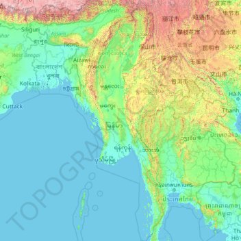
Name: Myanmar topographic map, elevation, terrain.
Location: Myanmar (9.52608 92.17292 28.54784 101.17008)
Average elevation: 569 m
Minimum elevation: -3 m
Maximum elevation: 7,762 m
Make a donation
Other topographic maps
Click on a map to view its topography, its elevation and its terrain.
Istanbul
Istanbul, located in northwestern Turkey, is a city that is uniquely situated across two continents, Europe and Asia, divided by the Bosphorus Strait. The city’s topography is characterized by a complex blend of hills, valleys, and coastal plains, which create a varied and scenic landscape. The European side…
Average elevation: 57 m
Hong Kong
Hong Kong has a humid subtropical climate (Köppen Cwa), characteristic of southern China. Summer is hot and humid, with occasional showers and thunderstorms and warm air from the southwest. Typhoons occur most often then, sometimes resulting in floods or landslides. Winters are mild and usually sunny at the…
Average elevation: 62 m
Chiang Mai
Chiang Mai has a tropical savanna climate (Köppen Aw), tempered by the low latitude and moderate elevation, with warm to hot weather year-round, though nighttime conditions during the dry season can be cool and much lower than daytime highs. The maximum temperature ever recorded was 42.4 °C (108.3 °F) in…
Average elevation: 424 m
Make a donation
Make a donation
Make a donation
Make a donation
Cajon Pass
United States > California > San Bernardino County
Cajon Pass (/kəˈhoʊn/; Spanish: Puerto del Cajón or Paso del Cajón) is a mountain pass between the San Bernardino Mountains to the east and the San Gabriel Mountains to the west in Southern California. Created by the movements of the San Andreas Fault, it has an elevation of 3,777 ft (1,151 m). Located in…
Average elevation: 1,169 m
Bangladesh
With an elevation of 1,064 m (3,491 ft), Saka Haphong (also known as Mowdok Mual) near the border with Myanmar, is claimed to be the highest peak of Bangladesh. However, it is not yet widely recognized as the highest point of the country, and most sources give the honor to Keokradong.
Average elevation: 1,488 m
Skardu
Pakistan > Gilgit-Baltistan > Skardu District
Skardu (Urdu: سکردو, romanised: skardū, Tibetan script: སྐར་མདོ, pronounced [skərduː]) is a city located in Pakistan-administered Gilgit-Baltistan in the disputed Kashmir region. Skardu serves as the capital of Skardu District and the Baltistan Division. It is situated at an average…
Average elevation: 3,423 m
Make a donation
Shiyan
The far northern and southern reaches of Shiyan are the highest in elevation, while the geographic center of the city has a relatively low elevation. The highest point in Shiyan is Congping in Zhuxi County, at 2,740.2 metres (8,990 ft) above sea level, while the lowest point, Panjiayan in Danjiangkou, is 87…
Average elevation: 422 m
Make a donation
Make a donation
Make a donation
Ankara
Ankara has a cold semi-arid climate (Köppen climate classification: BSk). Under the Trewartha climate classification, Ankara has a temperate humid continental climate (Dc). Due to its elevation and inland location, Ankara has cold and snowy winters, and hot and dry summers. Rainfall occurs mostly during the…
Average elevation: 1,082 m
Molave
Philippines > Zamboanga del Sur
Molave is divided into two topographical areas. The east and southwest lowlands, which cover 30 percent of its total land area, consist of nine barangays and are generally flat, swampy and marshy. The upland, which covers 70 percent of Molave's total area, is hilly and mostly deforested. The terrain is…
Average elevation: 41 m
Make a donation
Make a donation
Africa
Average elevation: 462 m
Toconao
Chile > Antofagasta Region > Provincia de El Loa > San Pedro de Atacama
Toconao is a village 38 km (24 mi) south of San Pedro de Atacama in the San Pedro de Atacama province of Chile's northern Antofagasta Region. It lies at an elevation of 2,485 m (8,153 ft) above sea level, close to the northeast margin of the Salar de Atacama.
Average elevation: 2,488 m
Make a donation
Međugorje
Bosnia and Herzegovina > Federation of Bosnia and Herzegovina
The name Međugorje literally means "between mountains". At an altitude of 200 m (660 ft) above sea level it has a mild Mediterranean climate. The town consists of an ethnically homogeneous Croat population of 2,306. The Catholic parish includes four neighbouring villages: Bijakovići, Vionica, Miletina and…
Average elevation: 203 m
Make a donation
Make a donation
Make a donation
Matsulu
South Africa > Mpumalanga > Ehlanzeni District Municipality > Mbombela
Average elevation: 449 m
Make a donation
Make a donation
Make a donation
Sutton
United Kingdom > England > London
Elevations in and around the town range from 115 metres (377 ft) AOD in Belmont to 23 metres (75 ft) in Sutton Common, at the start of the Pyl Brook stream.
Average elevation: 63 m
Little Hagley Park
New Zealand > Canterbury > Christchurch City > Linwood-Central-Heathcote Community
Average elevation: 12 m
Make a donation
Balfour
Canada > British Columbia > Regional District of Central Kootenay > Area E (Balfour/Cottonwood Lake)
Average elevation: 673 m
Make a donation
Sithonia
Greece > Macedonia and Thrace > Chalkidiki Regional Unit > Toroni Municipal Unit
Average elevation: 473 m
Make a donation
Doi Suthep
Doi Suthep (ดอยสุเทพ), is a mountain ("doi") west of Chiang Mai, Thailand. It is 1,676 metres (5,499 ft) in elevation and is one of the twin peaks of a granite mountain. The other peak is known as Doi Pui and is slightly higher (1,685 metres (5,528 ft)).
Average elevation: 1,351 m
Make a donation
Make a donation
Wonderkop Nature Reserve
South Africa > Limpopo > Capricorn District Municipality
Average elevation: 904 m
Mount Royal
Canada > Quebec > Urban agglomeration of Montreal > Montreal
The mountain is part of the Monteregian Hills situated between the Laurentians and the Appalachian Mountains. It gave its Latin name, Mons Regius, to the Monteregian chain. The mountain consists of three peaks: Colline de la Croix (or Mont Royal proper) at 233 m (764 ft), Colline d'Outremont (or Mount Murray,…
Average elevation: 111 m
Make a donation
Chongqing
The central urban area of Chongqing, or Chongqing proper, is a city of unique features. Built on mountains and partially surrounded by the Yangtze and Jialing rivers, it is known as a "mountain city" and a "city on rivers". The night scene of the city is very illuminated, with millions of lights and their…
Average elevation: 318 m
Make a donation
Mount Apo
Philippines > Davao del Sur > Bansalan
Mount Apo is the highest mountain peak in the Philippines, with an elevation of 2,954 meters (9,692 ft) above sea level. A large solfataric, dormant stratovolcano, it is part of the Apo-Talomo Mountain Range of Mindanao island. Apo is situated on the tripartite border of Davao City, Davao del Sur, and…
Average elevation: 2,416 m
Make a donation