
Asia topographic map
Interactive map
Click on the map to display elevation.
About this map
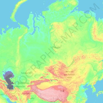
Name: Asia topographic map, elevation, terrain.
Location: Asia (26.20870 64.23437 76.20870 114.23437)
Average elevation: 563 m
Minimum elevation: -30 m
Maximum elevation: 7,348 m
Other topographic maps
Click on a map to view its topography, its elevation and its terrain.
Pulau Bali
Bali's central mountains include several peaks over 2,000 metres (6,600 feet) in elevation and active volcanoes such as Mount Batur. The highest is Mount Agung (3,031 m; 9,944 ft), known as the "mother mountain", which is an active volcano rated as one of the world's most likely sites for a massive eruption…
Average elevation: 122 m
Hallstatt
Austria > Upper Austria > Bezirk Gmunden
The Hallstatt salt mine is the world's oldest working salt mine. The mine is located within the Upper Permian to Lower Triassic Haselgebirge Formation of the Northern Limestone Alps. The Hallstatt salt mine comprises 21 levels and several smaller shafts ranging from 514 metres (1,686 ft) above sea level…
Average elevation: 1,514 m
Norway
At 385,207 square kilometres (148,729 sq mi) (including Svalbard and Jan Mayen; 323,808 square kilometres (125,023 sq mi) without), much of the country is dominated by mountainous or high terrain, with a great variety of natural features caused by prehistoric glaciers and varied topography. The most noticeable…
Average elevation: 143 m
Peterborough
Peterborough's topography is largely defined by land formations created by the receding Wisconsian glaciers 10,000–15,000 years ago. The South End and Downtown portions of the city sit on what was the bottom of the glacial Lake Peterborough—part of a glacial spillway created when glacial meltwaters from…
Average elevation: 232 m
North Western Province
The North Western Province is characterised by a variety of topographical and climatic conditions, ranging from coastal regions with a tropical climate to inland areas that experience a more varied climate. The region features several prominent water bodies, including the Puttalam Lagoon, Mundal Lagoon, and…
Average elevation: 66 m
Wales
Much of Wales's diverse landscape is mountainous, particularly in the north and central regions. The mountains were shaped during the last ice age, the Devensian glaciation. The highest mountains in Wales are in Snowdonia (Eryri), of which five are over 1,000 m (3,300 ft). The highest of these is Snowdon (Yr…
Average elevation: 99 m
Zermatt
Switzerland > Wallis > Visp
It lies at the upper end of Mattertal at an elevation of 1,620 m (5,310 ft), at the foot of Switzerland's highest peaks. It lies about 10 km (6.2 mi) from the over 3,292 m (10,801 ft) high Theodul Pass bordering Italy. Zermatt is the southernmost commune of the German Sprachraum.
Average elevation: 2,921 m
Telluride
United States > Colorado > San Miguel County
Telluride has an elevation of 8,750 feet (2,670 m) in an isolated spot in Southwest Colorado. From the west, Colorado Route 145 is the most common way into Telluride; two other passes enter the town, Imogene Pass and Black Bear Pass.
Average elevation: 3,125 m
Wyoming
Wyoming's western half consists mostly of the ranges and rangelands of the Rocky Mountains; its eastern half consists of high-elevation prairie, and is referred to as the High Plains. Wyoming's climate is semi-arid in some parts and continental in others, making it drier and windier overall than other states,…
Average elevation: 1,938 m
Barents Sea
There are three main types of water masses in the Barents Sea: Warm, salty Atlantic water (temperature >3 °C, salinity >35) from the North Atlantic drift; cold Arctic water (temperature <0 °C, salinity <35) from the north; and warm, but not very salty, coastal water (temperature >3 °C, salinity <34.7).…
Average elevation: 45 m
Turkey
Turkey's topography is a diverse tapestry of mountains, plateaus, and coastal plains that create a strikingly varied landscape. The country is predominantly characterized by the Anatolian Plateau, a semi-arid highland that stretches across central Turkey, with elevations ranging from 700 to 2,000 meters. This…
Average elevation: 487 m
Parque Andino Juncal
Chile > Valparaiso Region > Provincia de Los Andes > Los Andes
Average elevation: 3,807 m
Stewart Island
Although the clay soil is not very fertile, the high rainfall and warm weather mean that the island is densely forested throughout. Native plants include the world's southernmost dense forest of podocarps (southern conifers) and hardwoods such as rātā and kāmahi in the lowland areas with mānuka shrubland…
Average elevation: 63 m
Tawang
Tawang district, the basin of Tawang Chu, occupies an area of 2,172 square kilometres (839 sq mi),. The district is roughly located around latitude 27° 45’ N and longitude 90° 15’ E at the northwest extremity of Arunachal Pradesh. Elevations range between 6,000 and 22,000 feet (6,700 m), and inhabitants…
Average elevation: 3,767 m
Stanford in the Vale
United Kingdom > England > Oxfordshire > Vale of White Horse
Average elevation: 80 m
Basalt Island
China > Hong Kong > Sai Kung District
Basalt Island is located south of Town Island and Wang Chau, east of Bluff Island and north of the Ninepin Group. Its highest elevation is 174 m. Notably, despite its name is “Basalt Island”, the rocks that forms the island are indeed rhyolitic tuff.
Average elevation: 6 m
Markham
Canada > Ontario > York Region
Markham's average altitude is at 200 m (660 ft) and in general consists of gently rolling hills. The city is intersected by two rivers; the Don River and Rouge River, as well as their tributaries. To the north is the Oak Ridges Moraine, which further elevates the elevation towards the north.
Average elevation: 216 m
Sibu
Malaysia > Sarawak > Sibu > Sibu
Sibu is located near the Rajang delta at the confluence of Rajang and Igan rivers. Peat swamp forests and alluvial plains are particularly prevalent in the Sibu Division. Sibu is located on a deep peat soil, which has caused problems in infrastructure development because buildings and roads slowly sink into…
Average elevation: 9 m
Israel
Temperatures vary widely, especially during the winter. Coastal areas, such as those of Tel Aviv and Haifa, have a typical Mediterranean climate with cool, rainy winters and long, hot summers. The area of Beersheba and the northern Negev have a semi-arid climate with hot summers, cool winters, and fewer rainy…
Average elevation: 410 m
Ardennes
Covering 5,229 square kilometres (2,019 square miles), the department was the smallest among the four contributors to Champagne-Ardenne. It is diverse in climate, topography, natural vegetation and land use, which is a mixture of forest and arable farming.
Average elevation: 225 m
Newark
United States > New Jersey > Essex County
According to the United States Census Bureau, the city had a total area of 25.89 square miles (67.1 km2), including 24.14 square miles (62.5 km2) of land and 1.74 square miles (4.5 km2) of water (6.72%). It has the third-smallest land area among the 100 most populous cities in the U.S., behind neighboring…
Average elevation: 22 m
Wainfleet All Saints
United Kingdom > England > Lincolnshire > East Lindsey > Wainfleet St Mary
Average elevation: 3 m
Chicago
United States > Illinois > Cook County
When Chicago was founded in 1837, most of the early building was around the mouth of the Chicago River, as can be seen on a map of the city's original 58 blocks. The overall grade of the city's central, built-up areas is relatively consistent with the natural flatness of its overall natural geography,…
Average elevation: 182 m
Jiuzhaigou County
The county consists of nine villages in a valley in Sichuan Province. The main ethnic group in the county is Han, with the second being Tibetan. The county seat has an altitude of about 1,400 m (4,600 ft). It has a total area of 2,041 square miles (5,286 km2). As of 2015, the county's total population was…
Average elevation: 3,201 m
Transylvania County
United States > North Carolina
Transylvania County is known as the "Land of Waterfalls", due to it having over 250 waterfalls. This is due to a combination of its high precipitation and location on the Blue Ridge Escarpment. Notable waterfalls in the county include Looking Glass Falls, Moore Cove Falls, Rainbow Falls, and Whitewater Falls,…
Average elevation: 898 m
Burlington
United States > Massachusetts > Middlesex County
Located in the Greater Boston Area of eastern Massachusetts, Burlington is bordered by Bedford on the west, Billerica on the north, Wilmington on the northeast, Woburn on the southeast, and Lexington on the south. Burlington is 12 miles (19 km) south of Lowell, 12 miles (19 km) northwest of Boston, 36 miles…
Average elevation: 44 m
Isle of Man
Average elevation: 13 m
Stetson-Piney Island Reserve
United States > Massachusetts > Bristol County > Dartmouth > Great Neck
Average elevation: 0 m
Olympia
United States > Washington > Thurston County
The area is located near the southern limit of the Fraser Glaciation and the underlying sediments consist largely of Vashon-age till and outwash deposited at that time; the area also includes former lakebeds and alluvial deposits associated with proglacial lakes that existed in the area near the end of…
Average elevation: 49 m
Vaal Dam
South Africa > Free State > Fezile Dabi District Municipality > Metsimaholo Local Municipality > Deneysville
Average elevation: 1,481 m
Pangil
The municipality is strategically situated at the southern tip of Sierra Madre mountain range (six barangays) and along the eastern margin of Jalajala Peninsula and just west of the northwestern shore of the easternmost major embayment of Laguna de Bay (two barangays). Its narrow strip of territory traverses…
Average elevation: 165 m
Rutog County
Rutog County is located in northwestern Tibet, in the Ngari Prefecture, with a number of territorial borders. It is divided into 12 townships and 30 village committees. The average altitude of the county is 4,500 m (14,800 ft) with a maximum altitude of 6,800 m (22,300 ft).
Average elevation: 5,137 m
Highfields
Along with Meringandan, the climate is oceanic (Köppen: Cfb) due to elevation, usually located further south of Australia.
Average elevation: 588 m
Beatenberg
Switzerland > Bern > Interlaken-Oberhasli administrative district
Average elevation: 1,281 m