
Make a donation
Little Birch topographic map
Click on the map to display elevation.
Make a donation
About this map
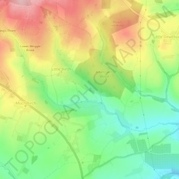
Name: Little Birch topographic map, elevation, terrain.
Location: Little Birch, Herefordshire, England, United Kingdom (51.95807 -2.72340 51.98951 -2.67630)
Average elevation: 139 m
Minimum elevation: 55 m
Maximum elevation: 240 m
Make a donation
Other topographic maps
Click on a map to view its topography, its elevation and its terrain.
Make a donation
Make a donation
Make a donation
Make a donation
Make a donation
Make a donation
Hergest Ridge
United Kingdom > England > Herefordshire
Hergest Ridge is a large elongated hill which traverses the border between England and Wales in the United Kingdom, between the town of Kington in Herefordshire and the village of Gladestry in Powys. Its highest point, which is in England, is 426 metres (1,398 ft) high. It has a topographic prominence of 157.6…
Average elevation: 308 m
Make a donation
Make a donation
Bagpiper's Tump
United Kingdom > England > Herefordshire > Mordiford > Bagpiper's Tump
Average elevation: 88 m
Make a donation
Eastnor Deer Park
United Kingdom > England > Herefordshire > Eastnor > Wayend Street
Average elevation: 134 m
Make a donation
Bollitree Castle
United Kingdom > England > Herefordshire > Weston under Penyard
Average elevation: 87 m
Make a donation
Make a donation
Make a donation
Make a donation
Make a donation
Make a donation
Make a donation
Make a donation