
Make a donation
Neman River topographic map
Click on the map to display elevation.
Make a donation
About this map
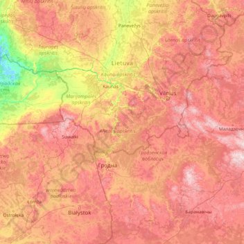
Name: Neman River topographic map, elevation, terrain.
Location: Neman River, Lithuania (53.34177 21.24807 55.34648 27.10895)
Average elevation: 130 m
Minimum elevation: -3 m
Maximum elevation: 340 m
Make a donation
Other topographic maps
Click on a map to view its topography, its elevation and its terrain.
Highest point of the A1 motorway
Lithuania > Taurage County > Kaltinėnų seniūnija > Prienai
Average elevation: 158 m
Make a donation
Make a donation
Medvėgalis
Lithuania > Taurage County > Laukuvos seniūnija > Buciškė
The Medvėgalis Mound, elevation 234.6 m, is the highest point in the Samogitian Upland
Average elevation: 185 m
Make a donation
Sablauskiai
Lithuania > Siauliai County > Naujosios Akmenės kaimiškoji seniūnija
Average elevation: 76 m
Make a donation
Make a donation
Make a donation
Make a donation
Make a donation
Make a donation
Make a donation
Make a donation
Make a donation
Make a donation
Kruopynė Hill
Lithuania > Vilnius County > Rukainių seniūnija
Kruopinė (Žybartonys) Hill is a hill near Vilnius which is the second-highest point in Lithuania. Its elevation is 293.65 metres.
Average elevation: 262 m
Make a donation
Make a donation
Make a donation
Aukštojas
Lithuania > Vilnius County > Medininkai Eldership > Juozapinė
Aukštojas Hill is the highest point of Lithuania. It is located in the Medininkai Highlands, Migūnai forestry, approximately 24 kilometres (15 mi) southeast of the capital city of Vilnius. Its elevation was measured in 2004 at 293.84 metres (964.0 feet) by specialists at the Institute of Geodesy at Vilnius…
Average elevation: 264 m
Make a donation
Make a donation
Make a donation
Make a donation
Biržai Radziwiłł Castle
Lithuania > Panevezys County > Biržų miesto seniūnija > Biržai
Average elevation: 54 m
Make a donation
Make a donation
Make a donation
Rietavas
Lithuania > Telsiai County > Rietavo miesto seniūnija > Rietavas > Rietavas
Average elevation: 113 m
Make a donation
Make a donation