
Thank you for supporting this site ❤️
Make a donation
Make a donation
Teulada topographic map
Click on the map to display elevation.
Thank you for supporting this site ❤️
Make a donation
Make a donation
About this map
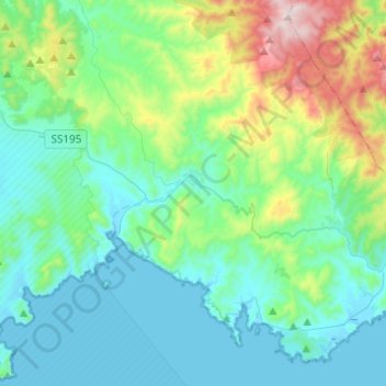
Name: Teulada topographic map, elevation, terrain.
Location: Teulada, Sud Sardegna, Sardinia, 09019, Italy (38.86401 8.60535 39.05515 8.84260)
Average elevation: 195 m
Minimum elevation: -2 m
Maximum elevation: 960 m
Thank you for supporting this site ❤️
Make a donation
Make a donation
Other topographic maps
Click on a map to view its topography, its elevation and its terrain.
Thank you for supporting this site ❤️
Make a donation
Make a donation
Salmagi
Italy > Sardinia > Casteddu/Cagliari > Quartu Sant'Aleni/Quartu Sant'Elena > Terra Mala
Average elevation: 60 m
Thank you for supporting this site ❤️
Make a donation
Make a donation
Thank you for supporting this site ❤️
Make a donation
Make a donation
Thank you for supporting this site ❤️
Make a donation
Make a donation
Thank you for supporting this site ❤️
Make a donation
Make a donation
Monte Arcosu
Italy > Sardinia > Casteddu/Cagliari > Siliqua
Monte Arcosu is a mountain in the Sulcis massif, in southern Sardinia, Italy. It has an elevation of 948 metres (3,110 ft).
Average elevation: 546 m
Thank you for supporting this site ❤️
Make a donation
Make a donation
Thank you for supporting this site ❤️
Make a donation
Make a donation
Torre Grande
Italy > Sardinia > Aristanis/Oristano > Aristanis/Oristano > Torregrande
Average elevation: 1 m
Thank you for supporting this site ❤️
Make a donation
Make a donation