
Make a donation
Nepal topographic map
Click on the map to display elevation.
Make a donation
Nepal
Nepal is divided into three principal physiographic belts known as Himal–Pahad–Terai. Himal is the mountain region containing snow and situated in the Great Himalayan Range; it makes up the northern part of Nepal. It contains the highest elevations in the world including 8,848.86 metres (29,032 ft) height Mount Everest (Sagarmāthā in Nepali) on the border with China. Seven other of the world's "eight-thousanders" are in Nepal or on its border with Tibet: Lhotse, Makalu, Cho Oyu, Kangchenjunga, Dhaulagiri, Annapurna and Manaslu. Pahad is the mountain region that does not generally contain snow. The mountains vary from 800 to 4,000 metres (2,600 to 13,100 ft) in altitude, with progression from subtropical climates below 1,200 metres (3,900 ft) to alpine climates above 3,600 metres (11,800 ft). The Lower Himalayan Range, reaching 1,500 to 3,000 metres (4,900 to 9,800 ft), is the southern limit of this region, with subtropical river valleys and "hills" alternating to the north of this range. Population density is high in valleys but notably less above 2,000 metres (6,600 ft) and very low above 2,500 metres (8,200 ft), where snow occasionally falls in winter. The southern lowland plains or Terai bordering India are part of the northern rim of the Indo-Gangetic Plain. Terai is the lowland region containing some hill ranges. The plains were formed and are fed by three major Himalayan rivers: the Koshi, the Narayani, and the Karnali as well as smaller rivers rising below the permanent snowline. This region has a subtropical to tropical climate. The outermost range of the foothills called Sivalik Hills or Churia Range, cresting at 700 to 1,000 metres (2,300 to 3,280 ft), marks the limits of the Gangetic Plain. Broad, low valleys called Inner Terai Valleys (Bhitri Tarai Upatyaka) lie north of these foothills in several places.
Make a donation
About this map
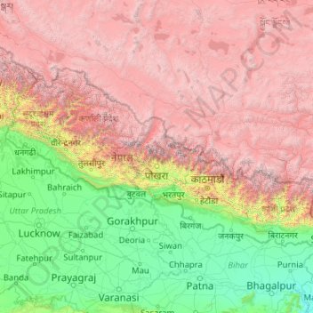
Name: Nepal topographic map, elevation, terrain.
Location: Nepal (26.34776 80.05708 30.44695 88.20153)
Average elevation: 2,583 m
Minimum elevation: 22 m
Maximum elevation: 8,152 m
Make a donation
Other topographic maps
Click on a map to view its topography, its elevation and its terrain.
Istanbul
Istanbul, located in northwestern Turkey, is a city that is uniquely situated across two continents, Europe and Asia, divided by the Bosphorus Strait. The city’s topography is characterized by a complex blend of hills, valleys, and coastal plains, which create a varied and scenic landscape. The European side…
Average elevation: 57 m
Chiang Mai
Chiang Mai has a tropical savanna climate (Köppen Aw), tempered by the low latitude and moderate elevation, with warm to hot weather year-round, though nighttime conditions during the dry season can be cool and much lower than daytime highs. The maximum temperature ever recorded was 42.4 °C (108.3 °F) in…
Average elevation: 424 m
Bangladesh
With an elevation of 1,064 m (3,491 ft), Saka Haphong (also known as Mowdok Mual) near the border with Myanmar, is claimed to be the highest peak of Bangladesh. However, it is not yet widely recognized as the highest point of the country, and most sources give the honor to Keokradong.
Average elevation: 1,488 m
Make a donation
Kastelli
Greece > Region of Crete > Heraklion Regional Unit > Kastelli Municipal Unit
Average elevation: 366 m
Make a donation
Make a donation
Rangamati
Bangladesh > Chattogram Division > Rangamati Sadar Upazila
Rangamati (Bengali: রাঙামাটি) is a town and the administrative headquarters of Rangamati District in the Chittagong Hill Tracts of Bangladesh. The town is located at 22°37'60N 92°12'0E and has an elevation of 14 metres (46 ft) above sea level.
Average elevation: 68 m
Make a donation
Make a donation
Make a donation
Make a donation
Aberlour
United Kingdom > Scotland > Moray
According to the 1846 A Topographical Dictionary of Scotland, "This parish, formerly called Skirdustan, signifying, in the Gaelic tongue, 'the division of Dustan', its tutelary saint, derived its present name from its situation at the mouth of a noisy burn, which discharges itself into the river Spey."
Average elevation: 160 m
Holeta Genet
Ethiopia > Oromia Region > Walmara
Holeta (Amharic: ሆለታ) (Oromo: Holataa) is a town in the special zone of Oromia Region, Ethiopia. It has a latitude and longitude of 9°3′N 38°30′E / 9.050°N 38.500°E / 9.050; 38.500 and an altitude of 2391 meters above sea level.
Average elevation: 2,391 m
Make a donation
Make a donation
Make a donation
Mount Royal
Canada > Quebec > Urban agglomeration of Montreal > Montreal
The mountain is part of the Monteregian Hills situated between the Laurentians and the Appalachian Mountains. It gave its Latin name, Mons Regius, to the Monteregian chain. The mountain consists of three peaks: Colline de la Croix (or Mont Royal proper) at 233 m (764 ft), Colline d'Outremont (or Mount Murray,…
Average elevation: 111 m
Make a donation
Make a donation
Make a donation
Make a donation
Maseru
Maseru is located in northwest Lesotho by the South African border, denoted by the Mohokare River, also known as Caledon River. The two countries are connected by a border post at the Maseru Bridge, which crosses the river. On the South African side, Ladybrand is the town closest to Maseru. The city lies in a…
Average elevation: 1,606 m
Featherston
New Zealand > Wellington > South Wairarapa District > Featherston Community
Average elevation: 125 m
Make a donation
Make a donation
Make a donation
Make a donation
Make a donation
Make a donation
Make a donation
Phu Kradung
Thailand > Phu Kradueng District
Phu Kradueng National Park (Thai: อุทยานแห่งชาติภูกระดึง), in the Si Than sub-district of Amphoe Phu Kradueng, Loei Province, is a national park in Thailand. It has a high point of 1,316 m (4318 ft) elevation at Khok Moei. It was proclaimed a national park on 23…
Average elevation: 1,183 m
Chattogram
Bangladesh > Chattogram Division > Chittagong City
Chittagong lies at 22°20′06″N 91°49′57″E / 22.33500°N 91.83250°E / 22.33500; 91.83250. It straddles the coastal foothills of the Chittagong Hill Tracts in south-eastern Bangladesh. The Karnaphuli River runs along the southern banks of the city, including its central business district. The…
Average elevation: 6 m
Make a donation
Floreaga
Spain > Autonomous Community of the Basque Country > Urola-Kosta > Azkoitia
Average elevation: 266 m
Make a donation
Anbar sar
Iran > Gilan Province > Astaneh-ye Ashrafiyeh County > دهستان دهگاه
Average elevation: -25 m
Make a donation
Murree
Pakistan > Punjab > Murree District
Murree is a mountain resort city in the northernmost region of the Punjab province of Pakistan. Lying in the Galyat region of the Pir Panjal Range under the western Himalayas, it is located in the northeast of the capital city of Islamabad. The town was built in the mid-19th century and served as the summer…
Average elevation: 1,718 m
Make a donation