
Mid-Western Development Region topographic map
Interactive map
Click on the map to display elevation.
About this map
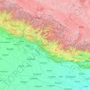
Name: Mid-Western Development Region topographic map, elevation, terrain.
Location: Mid-Western Development Region, Karnali Pradesh, Nepal (26.03861 79.08901 31.23861 84.28901)
Average elevation: 2,083 m
Minimum elevation: 56 m
Maximum elevation: 7,925 m
Other topographic maps
Click on a map to view its topography, its elevation and its terrain.
Khotang
Geographically, Khotang is a hilly district of Eastern Nepal. It lies on the coordinates of 260° 50" N to 270° 28" N latitude and 860° 26" E to 860° 58" E longitude. Coordinates of the center is 27° 11' 60.00" N and 86° 46' 59.99" E. Total area of the district is 1,591 square kilometres (614 sq mi). The…
Average elevation: 1,317 m
Rupandehi
The district lies on the southern and western part of Nepal. On the East it shares border with Nawalparasi District, on West with Kapilvastu District, on North with Palpa District and on South with India. The elevation of the district lies between 100m to 1229m from sea level. The total area of the district is…
Average elevation: 182 m
Pokhara
Pokhara (Nepali: पोखरा, Nepali pronunciation: [ˈpokʰʌɾa]) is a metropolitan city in Nepal, which serves as the capital of Gandaki Province. It is the second most populous city of Nepal after Kathmandu, with 518,452 inhabitants living in 101,669 households in 2021. It is the country's largest…
Average elevation: 1,203 m
Baglung
Highest temperature at the lowest elevation of baglung rises up to about 37.5 degrees Celsius in summer and the lowest temperature at Dhorpatan falls up to about −15 degrees Celsius in winter. The elevation of Baglung varies from about 650 meters at Kharbang to about 4,300 meters in Dhorpatan.
Average elevation: 2,326 m