
Thank you for supporting this site ❤️
Make a donation
Make a donation
Gorkha topographic map
Click on the map to display elevation.
Thank you for supporting this site ❤️
Make a donation
Make a donation
About this map
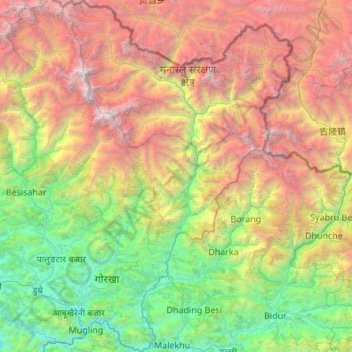
Name: Gorkha topographic map, elevation, terrain.
Location: Gorkha, Gandaki Pradesh, Nepal (27.79556 84.41869 28.75157 85.19783)
Average elevation: 2,862 m
Minimum elevation: 219 m
Maximum elevation: 8,003 m
Thank you for supporting this site ❤️
Make a donation
Make a donation
Other topographic maps
Click on a map to view its topography, its elevation and its terrain.
Pokhara
Pokhara (Nepali: पोखरा, Nepali pronunciation: ) is a metropolitan city in Nepal, which serves as the capital of Gandaki Province. It is the country's largest metropolitan city in terms of area and second-largest in terms of population. The city also serves as the headquarters of Kaski District.…
Average elevation: 1,222 m
Thank you for supporting this site ❤️
Make a donation
Make a donation