
Thank you for supporting this site ❤️
Make a donation
Make a donation
Tanahun topographic map
Click on the map to display elevation.
Thank you for supporting this site ❤️
Make a donation
Make a donation
About this map
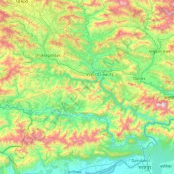
Name: Tanahun topographic map, elevation, terrain.
Location: Tanahun, Gandaki Pradesh, Nepal (27.74127 83.93656 28.12954 84.55924)
Average elevation: 692 m
Minimum elevation: 153 m
Maximum elevation: 2,073 m
Thank you for supporting this site ❤️
Make a donation
Make a donation
Other topographic maps
Click on a map to view its topography, its elevation and its terrain.
Pokhara
Pokhara (Nepali: पोखरा, Nepali pronunciation: ) is a metropolitan city in Nepal, which serves as the capital of Gandaki Province. It is the country's largest metropolitan city in terms of area and second-largest in terms of population. The city also serves as the headquarters of Kaski District.…
Average elevation: 1,222 m
Thank you for supporting this site ❤️
Make a donation
Make a donation