
Make a donation
Khotang topographic map
Click on the map to display elevation.
Make a donation
Khotang
Geographically, Khotang is a hilly district of Eastern Nepal. It lies on the coordinates of 260° 50" N to 270° 28" N latitude and 860° 26" E to 860° 58" E longitude. Coordinates of the center is 27° 11' 60.00" N and 86° 46' 59.99" E. Total area of the district is 1,591 square kilometres (614 sq mi). The elevations of the district is 152 m to 3620 m from the sea level. Sunkoshi River and Dudh Koshi river makes natural borders in the North, West and South and a series of hills and small river makes border separating it from Bhojpur District in East. Approximately 56% of the district area is covered with forest. And about 42% of the district area is under cultivation.
Make a donation
About this map
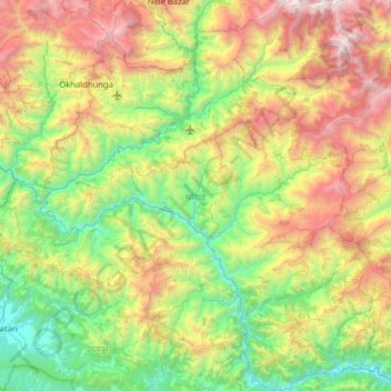
Name: Khotang topographic map, elevation, terrain.
Location: Khotang, Province #1, Nepal (26.87203 86.42649 27.43968 86.98490)
Average elevation: 1,317 m
Minimum elevation: 157 m
Maximum elevation: 3,623 m
Make a donation
Other topographic maps
Click on a map to view its topography, its elevation and its terrain.
Pokhara
Pokhara (Nepali: पोखरा, Nepali pronunciation: ) is a metropolitan city in Nepal, which serves as the capital of Gandaki Province. It is the country's largest metropolitan city in terms of area and second-largest in terms of population. The city also serves as the headquarters of Kaski District.…
Average elevation: 1,222 m
Make a donation