
Make a donation
Pokhara topographic map
Click on the map to display elevation.
Make a donation
Pokhara
Pokhara (Nepali: पोखरा, Nepali pronunciation: [ˈpokʰʌɾa]) is a metropolitan city in Nepal, which serves as the capital of Gandaki Province. It is the second most populous city of Nepal after Kathmandu, with 518,452 inhabitants living in 101,669 households in 2021. It is the country's largest metropolitan city in terms of area. The city also serves as the headquarters of Kaski District. Pokhara is located 200 kilometres (120 miles) west of the capital, Kathmandu. The city is on the shore of Phewa Lake, and sits at an elevation of approximately 822m. The Annapurna Range, with three out of the ten highest peaks in the world—Dhaulagiri, Annapurna I and Manaslu—is within 15–35 mi (24–56 km) of the valley.
Make a donation
About this map
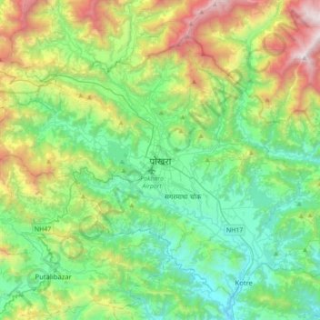
Name: Pokhara topographic map, elevation, terrain.
Location: Pokhara, Kaski, Gandaki Pradesh, Nepal (28.07773 83.79872 28.34122 84.14745)
Average elevation: 1,203 m
Minimum elevation: 485 m
Maximum elevation: 3,058 m
Make a donation
Other topographic maps
Click on a map to view its topography, its elevation and its terrain.
Pokhara
Pokhara (Nepali: पोखरा, Nepali pronunciation: ) is a metropolitan city in Nepal, which serves as the capital of Gandaki Province. It is the country's largest metropolitan city in terms of area and second-largest in terms of population. The city also serves as the headquarters of Kaski District.…
Average elevation: 1,222 m