
开阳县 topographic map
Interactive map
Click on the map to display elevation.
About this map
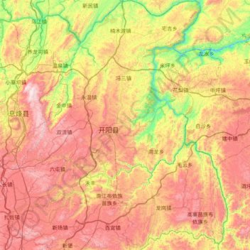
Name: 开阳县 topographic map, elevation, terrain.
Location: 开阳县, 贵阳市, 贵州省, 中国 (26.78153 106.74093 27.35999 107.27469)
Average elevation: 1,095 m
Minimum elevation: 519 m
Maximum elevation: 1,730 m
Other topographic maps
Click on a map to view its topography, its elevation and its terrain.