
夏河县 topographic map
Interactive map
Click on the map to display elevation.
About this map
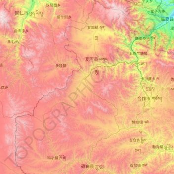
Name: 夏河县 topographic map, elevation, terrain.
Location: 夏河县, 甘南藏族自治州, 甘肃省, 中国 (34.53654 101.91499 35.58838 102.97387)
Average elevation: 3,409 m
Minimum elevation: 2,024 m
Maximum elevation: 4,757 m
距县城10公里。桑科草原属于草甸草原,平均海拔在3000米以上,草原面积达70平方公里,是甘南藏族自治州的主要畜牧业基地之一。
Other topographic maps
Click on a map to view its topography, its elevation and its terrain.