
忠和村 topographic map
Interactive map
Click on the map to display elevation.
About this map
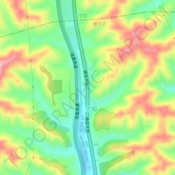
Name: 忠和村 topographic map, elevation, terrain.
Location: 忠和村, 盐场路街道, 城关区, 兰州市, 甘肃省, 中国 (36.17656 103.81948 36.18862 103.82346)
Average elevation: 1,762 m
Minimum elevation: 1,673 m
Maximum elevation: 1,874 m
Other topographic maps
Click on a map to view its topography, its elevation and its terrain.