
沂水县 topographic map
Interactive map
Click on the map to display elevation.
About this map
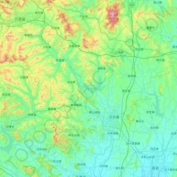
Name: 沂水县 topographic map, elevation, terrain.
Location: 沂水县, 临沂市, 山东省, 276400, 中国 (35.59932 118.18841 36.20646 119.06136)
Average elevation: 264 m
Minimum elevation: 100 m
Maximum elevation: 1,017 m
Other topographic maps
Click on a map to view its topography, its elevation and its terrain.