
鄠邑区 topographic map
Interactive map
Click on the map to display elevation.
About this map
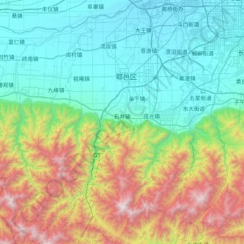
Name: 鄠邑区 topographic map, elevation, terrain.
Location: 鄠邑区, 西安市, 陕西省, 710300, 中国 (33.76485 108.36614 34.26574 108.76877)
Average elevation: 1,060 m
Minimum elevation: 387 m
Maximum elevation: 3,000 m
Other topographic maps
Click on a map to view its topography, its elevation and its terrain.