Geolocate

Skye topographic map

Interactive map

Click on the map to display elevation.

About this map

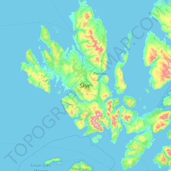
Name: Skye topographic map, elevation, terrain.

Location: Skye, Highland, Scotland, United Kingdom (57.01782 -6.78982 57.70821 -5.64713)

Average elevation: 63 m

Minimum elevation: 0 m

Maximum elevation: 918 m

Other topographic maps

Click on a map to view its topography, its elevation and its terrain.

Loch Ewe

United Kingdom > Scotland > Highland > Poolewe

Average elevation: 64 m

Bruray

United Kingdom > Scotland > Shetland

Average elevation: 2 m

Scottish Highlands

United Kingdom > Scotland > Highland

The entire region was covered by ice sheets during the Pleistocene ice ages, save perhaps for a few nunataks. The complex geomorphology includes incised valleys and lochs carved by the action of mountain streams and ice, and a topography of irregularly distributed mountains whose summits have similar heights…

Average elevation: 907 m

Moray

United Kingdom > Scotland

Average elevation: 280 m

Tornagrain

United Kingdom > Scotland > Highland

Average elevation: 51 m

Cawdor

United Kingdom > Scotland > Highland

Average elevation: 77 m

Glencoe

United Kingdom > Scotland > Highland

Average elevation: 114 m

Inveroran

United Kingdom > Scotland > Argyll and Bute

Average elevation: 227 m

Isle of Arran

United Kingdom > Scotland > North Ayrshire

The island has three endemic species of tree, the Arran whitebeams. These trees are the Scottish or Arran whitebeam (Sorbus arranensis), the bastard mountain ash or cut-leaved whitebeam (Sorbus pseudofennica) and the Catacol whitebeam (Sorbus pseudomeinichii). If rarity is measured by numbers alone they are…

Average elevation: 98 m

Inverness

United Kingdom > Scotland > Inverness

Average elevation: 163 m

Orkney Islands

United Kingdom > Scotland > Nesstoun

The southern group of islands surrounds Scapa Flow. Hoy is the second largest of the Orkney Isles and Ward Hill at its northern end is the highest elevation in the archipelago. The Old Man of Hoy is a well-known seastack. Burray lies to the east of Scapa Flow and is linked by causeway to South Ronaldsay, which…

Average elevation: 9 m

Newmains

United Kingdom > Scotland > Newmains

Average elevation: 163 m

East Kilbride

United Kingdom > Scotland > East Kilbride

Average elevation: 177 m

Alltsigh

United Kingdom > Scotland > Alltsigh

Average elevation: 189 m

Millbank

United Kingdom > Scotland > Millbank

Average elevation: 181 m

Wishaw

United Kingdom > Scotland > Wishaw

Average elevation: 124 m

Mull

United Kingdom > Scotland

Average elevation: 122 m

Old Town

United Kingdom > Scotland > Edinburgh

Average elevation: 61 m

North Connel

United Kingdom > Scotland > North Connel

Average elevation: 19 m

Grampian Mountains

United Kingdom > Scotland

Average elevation: 775 m

West End

United Kingdom > Scotland > Edinburgh

Average elevation: 59 m

Aberdeen

United Kingdom > Scotland > Aberdeen

Average elevation: 52 m

Caldervale

United Kingdom > Scotland > Haughhead

Average elevation: 33 m

Ben Nevis

United Kingdom > Scotland > Highland

Average elevation: 912 m

Waterton

United Kingdom > Scotland > Waterton

Average elevation: 32 m

Cairnsmore of Fleet

United Kingdom > Scotland

Average elevation: 489 m

Cairngorm Mountains

United Kingdom > Scotland

Average elevation: 937 m