
Make a donation
Moray topographic map
Click on the map to display elevation.
Make a donation
About this map
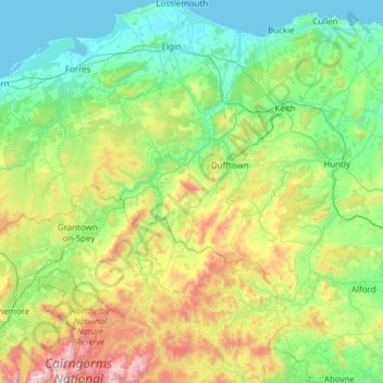
Name: Moray topographic map, elevation, terrain.
Location: Moray, Scotland, United Kingdom (57.06845 -3.76579 57.72671 -2.64982)
Average elevation: 280 m
Minimum elevation: 0 m
Maximum elevation: 1,309 m
Make a donation
Other topographic maps
Click on a map to view its topography, its elevation and its terrain.
Glasgow
United Kingdom > Scotland > Glasgow City
Glasgow itself was reputed to have been founded by the Christian missionary Saint Mungo in the 6th century. He established a church on the Molendinar Burn, where the present Glasgow Cathedral stands, and in the following years Glasgow became a religious centre. Glasgow grew over the following centuries as part…
Average elevation: 128 m
Scottish Highlands
United Kingdom > Scotland > Highland
The entire region was covered by ice sheets during the Pleistocene ice ages, save perhaps for a few nunataks. The complex geomorphology includes incised valleys and lochs carved by the action of mountain streams and ice, and a topography of irregularly distributed mountains whose summits have similar heights…
Average elevation: 907 m
Make a donation
Make a donation
Make a donation