
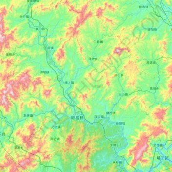
顺昌县 topographic map
Interactive map
Click on the map to display elevation.
About this map
Name: 顺昌县 topographic map, elevation, terrain.
Location: 顺昌县, 南平市, 福建省, 中国 (26.63716 117.49859 27.19816 118.24774)
Average elevation: 414 m
Minimum elevation: 59 m
Maximum elevation: 1,410 m
全县东西长74公里,南北宽61公里,境域总面积1979.5平方公里。其中陆地面积1948.87平方公里,占总面积98.18%;水域面积36.13平方公里,占1.82%。县城海拔129米。
Other topographic maps
Click on a map to view its topography, its elevation and its terrain.